IMAGES TAKEN NEAR TO
Green Close, SALISBURY, SP5 2SB
Introduction
This page details the photographs taken nearby to Green Close, SP5 2SB by members of the Geograph project.
The Geograph project started in 2005 with the aim of publishing, organising and preserving representative images for every square kilometre of Great Britain, Ireland and the Isle of Man.

There are currently over 7.5m images from over14,400 individuals and you can help contribute to the project by visiting https://www.geograph.org.uk
Image Map (Loading...)


Getting Data...Please wait
Leaflet Map data © OpenStreetMap
Images are licensed for reuse under creativecommons.org/licenses/by-sa/2.0
Notes
- Clicking on the map will re-center to the selected point.
- The higher the marker number, the further away the image location is from the centre of the postcode.
Image Listing (125 Images Found)
Images are licensed for reuse under creativecommons.org/licenses/by-sa/2.0
Image
Details
Distance
1
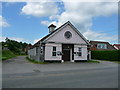
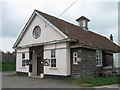
Whiteparish - Village Hall
The village hall stands near the Parish Lantern public house.
Image: © Chris Talbot
Taken: 12 Jun 2010
0.03 miles
5
Village Hall, Whiteparish
Due for redevelopment as 2 dwellings
Image: © Alex McGregor
Taken: 14 Apr 2011
0.07 miles
8
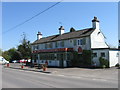
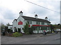
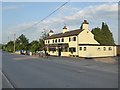
Whiteparish - The Parish Lantern
The Parish Lantern public house.
Image: © Chris Talbot
Taken: 12 Jun 2010
0.10 miles
9
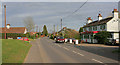
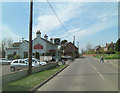
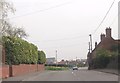
Romsey Road, Whiteparish
The Parish Lantern on right, the village hall on left.
Image: © Peter Facey
Taken: 16 Mar 2007
0.10 miles
10
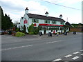
Whiteparish: the 'Parish Lantern'
Pub by the A27.
Image: © Stefan Czapski
Taken: 6 Jun 2018
0.12 miles