IMAGES TAKEN NEAR TO
Parkwater Lane, SALISBURY, SP5 2QR
Introduction
This page details the photographs taken nearby to Parkwater Lane, SP5 2QR by members of the Geograph project.
The Geograph project started in 2005 with the aim of publishing, organising and preserving representative images for every square kilometre of Great Britain, Ireland and the Isle of Man.

There are currently over 7.5m images from over14,400 individuals and you can help contribute to the project by visiting https://www.geograph.org.uk
Image Map (Loading...)


Getting Data...Please wait
Leaflet Map data © OpenStreetMap
Images are licensed for reuse under creativecommons.org/licenses/by-sa/2.0
Notes
- Clicking on the map will re-center to the selected point.
- The higher the marker number, the further away the image location is from the centre of the postcode.
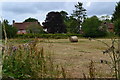
Image Listing (8 Images Found)
Images are licensed for reuse under creativecommons.org/licenses/by-sa/2.0
Image
Details
Distance
3
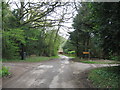
New Forest National Park sign, Parkwater Road
Image: © Alex McGregor
Taken: 14 Apr 2011
0.20 miles
4

Stream through bluebell meadow
Viewed from a bridge on Park Water Road
Image: © David Martin
Taken: 26 Apr 2007
0.20 miles

8
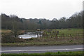
Pond near Cowesfield Green
This shot was taken looking south across the A27.
Image: © Anonymous 4452
Taken: 17 Mar 2006
0.24 miles