IMAGES TAKEN NEAR TO
Landford Wood, SALISBURY, SP5 2EU
Introduction
This page details the photographs taken nearby to SP5 2EU by members of the Geograph project.
The Geograph project started in 2005 with the aim of publishing, organising and preserving representative images for every square kilometre of Great Britain, Ireland and the Isle of Man.

There are currently over 7.5m images from over14,400 individuals and you can help contribute to the project by visiting https://www.geograph.org.uk
Image Map
Images are licensed for reuse under creativecommons.org/licenses/by-sa/2.0
Notes
- Clicking on the map will re-center to the selected point.
- The higher the marker number, the further away the image location is from the centre of the postcode.
Image Listing (5 Images Found)
Images are licensed for reuse under creativecommons.org/licenses/by-sa/2.0
Image
Details
Distance
2
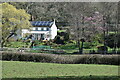
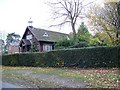
Gatehouse at Landford Wood
Formerly one of the gatehouses of the Melchet Court Estate.
Image: © David Martin
Taken: 21 May 2018
0.20 miles
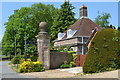
3
Gate and lodge at Landford Wood
One of the former gates to the Melchet Court Estate. The house is North Lodge which is mirrored by South Lodge, out of view to the right.
Image: © David Martin
Taken: 2 Apr 2021
0.20 miles
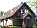
4
Landford Wood Mission Hall
Meetings began in a large room at Landford Wood Farm but the meeting outgrew the room and a hall was built in Landford Wood, on the estate of Louisa, Lady Ashburton. The hall was opened on 8th June 1899. By the mid 20th century the meeting had become a Free Evangelical Mission.
Image: © Maigheach-gheal
Taken: 9 Nov 2008
0.21 miles