IMAGES TAKEN NEAR TO
Southampton Road, SALISBURY, SP5 2EF
Introduction
This page details the photographs taken nearby to Southampton Road, SP5 2EF by members of the Geograph project.
The Geograph project started in 2005 with the aim of publishing, organising and preserving representative images for every square kilometre of Great Britain, Ireland and the Isle of Man.

There are currently over 7.5m images from over14,400 individuals and you can help contribute to the project by visiting https://www.geograph.org.uk
Image Map
Images are licensed for reuse under creativecommons.org/licenses/by-sa/2.0
Notes
- Clicking on the map will re-center to the selected point.
- The higher the marker number, the further away the image location is from the centre of the postcode.
Image Listing (8 Images Found)
Images are licensed for reuse under creativecommons.org/licenses/by-sa/2.0
Image
Details
Distance
2
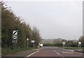
A36, Landford
Junction of the village road with the A36 at Landford.
Image: © Maigheach-gheal
Taken: 9 Nov 2008
0.03 miles
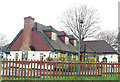
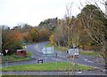
6
The Landford Poacher
The pub is situated on Pound Hill. The sign for the pub Image
Image: © Maigheach-gheal
Taken: 9 Nov 2008
0.09 miles
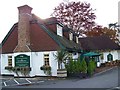
7

Sign for the Landford Poacher
The Poacher is a popular sign and here it is twinned with the name of the village.
Image: © Maigheach-gheal
Taken: 9 Nov 2008
0.11 miles
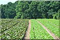
8

Mini Veg Packer
Salad crop being harvested.
Image: © David Martin
Taken: 11 Jun 2018
0.24 miles