IMAGES TAKEN NEAR TO
Easton Common Hill, SALISBURY, SP5 1QD
Introduction
This page details the photographs taken nearby to Easton Common Hill, SP5 1QD by members of the Geograph project.
The Geograph project started in 2005 with the aim of publishing, organising and preserving representative images for every square kilometre of Great Britain, Ireland and the Isle of Man.

There are currently over 7.5m images from over14,400 individuals and you can help contribute to the project by visiting https://www.geograph.org.uk
Image Map (Loading...)


Getting Data...Please wait
Leaflet Map data © OpenStreetMap
Images are licensed for reuse under creativecommons.org/licenses/by-sa/2.0
Notes
- Clicking on the map will re-center to the selected point.
- The higher the marker number, the further away the image location is from the centre of the postcode.
Image Listing (12 Images Found)
Images are licensed for reuse under creativecommons.org/licenses/by-sa/2.0
Image
Details
Distance
1
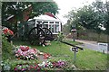
B&B in Middle Winterslow
This B&B has the good fortune to have brown tourist signs from the A30. You get a good welcome apparently if the gun carriage in the front garden is anything to go by. I do not have any vested interest in this establishment, just as an intrigued passer-by.
Image: © Graham Horn
Taken: 16 Aug 2008
0.09 miles
2
The Clarendon Way following the Roman road towards Middle Winterslow
Image: © Tim Heaton
Taken: 9 May 2010
0.10 miles
3
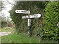
Old Direction Sign - Signpost by Gunville Hill, Winterslow parish
Pyramid top finial - 3 arms; by the UC road, in parish of Winterslow (Salisbury District), Middle Winterslow, crossroads at East of village.
Surveyed
Milestone Society National ID: WI_SU2532
Image: © Milestone Society
Taken: Unknown
0.14 miles
4
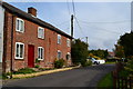
Cottages in Gunville Hill
These cottages are very close to the road: the red door does not appear to be used and door of the further cottage has been bricked up.
Image: © David Martin
Taken: 7 Oct 2012
0.17 miles
6
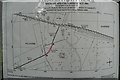
How the definitive map gets modified
Look closely at the plan and you will see that the footpath crosses from Wiltshire into Hampshire at point B and back into Wiltshire 54 metres later at point A, the county boundary going roughly north then east. It has been discovered that the footpath is on the Wiltshire definitive map (footpath Winterslow FP13) but does not appear on the Hampshire definitive map.
This notice, under the Wildlife and Countryside Act 1981, proposes a footpath modification order to add the missing bit to the Hampshire map, as West Tytherley FP18. This is important because otherwise the footpath will eventually be lost as a public right of way, but not if it is on the definitive map. The Countryside Rights Of Way Act 2003 put a limit of the year 2026 by which time the definitive maps will not accept any more changes.
So the moral is, get those public rights of way checked and pester your local council if they are not on the definitive map.
The Ordnance Survey maps (at all the main scales) show this footpath, including the Hampshire bit, so there is no guarantee that because it is on the OS map it is correct.
The context of the bit of footpath this plan refers to can be seen here Image]
I also have a photo of the page of text accompanying this map on the site, but it would be unreadable at Geograph scale, therefore I suggest that if anyone is interested in finding out more (using this as an example) they contact me.
Image: © Graham Horn
Taken: 16 Aug 2008
0.19 miles
7
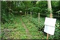
Missing footpath link
This is the section of "missing" footpath in Hampshire referred to in detail in this photo Image]
The path goes from Wiltshire into Hampshire here, for 54 metres, then back into Wiltshire but the Hampshire bit is not on the definitive map, thus a notice proposing a modification order.
Image: © Graham Horn
Taken: 16 Aug 2008
0.20 miles
8
Tytherley Road, view south-east
Residential development here seems suburban rather than rural.
Image: © Stefan Czapski
Taken: 6 Jun 2018
0.21 miles
9
Roman road through Middle Winterslow
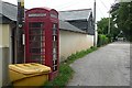
Part of the Roman road from Winchester (Venta) to Old Sarum (Sorviodvnvm) that is traceable virtually throughout. It will remain longer than the telephone box which is one of those scheduled for withdrawal.
Image: © Graham Horn
Taken: 16 Aug 2008
0.23 miles
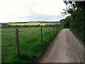
10
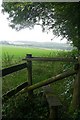
Farmland north of Middle Winterslow
Tempting, but this is not the footpath, which is a byway that stays with the woodland to the right.
Image: © Graham Horn
Taken: 16 Aug 2008
0.23 miles