IMAGES TAKEN NEAR TO
Red Lane, SALISBURY, SP5 1PT
Introduction
This page details the photographs taken nearby to Red Lane, SP5 1PT by members of the Geograph project.
The Geograph project started in 2005 with the aim of publishing, organising and preserving representative images for every square kilometre of Great Britain, Ireland and the Isle of Man.

There are currently over 7.5m images from over14,400 individuals and you can help contribute to the project by visiting https://www.geograph.org.uk
Image Map
Images are licensed for reuse under creativecommons.org/licenses/by-sa/2.0
Notes
- Clicking on the map will re-center to the selected point.
- The higher the marker number, the further away the image location is from the centre of the postcode.
Image Listing (11 Images Found)
Images are licensed for reuse under creativecommons.org/licenses/by-sa/2.0
Image
Details
Distance
1
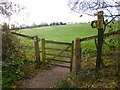
Middle Winterslow, gate
Across a field, from Red Lane to the village.
Image: © Mike Faherty
Taken: 7 Dec 2013
0.04 miles
2
Middle Winterslow, fallen tree
An ivy-entwined oak tree lying above Red Lane.
Image: © Mike Faherty
Taken: 7 Dec 2013
0.08 miles
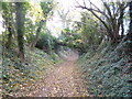
3
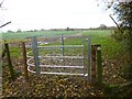
East Winterslow, kissing gate
One of several modern, efficient gates in the parish; on Red Lane, on the footpath across fields towards Hill Farm.
Image: © Mike Faherty
Taken: 7 Dec 2013
0.15 miles
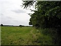
5
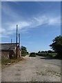
At Hill Farm
The view is roughly south-east. To the left of the hedge, the track leads to the working farm. On the right, the minor road is Mill Lane.
Image: © Stefan Czapski
Taken: 6 Jun 2018
0.17 miles
6
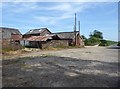
Disused farm buildings, Hill Farm
Still a working farm - though the active site now seems to be further south.
Image: © Stefan Czapski
Taken: 6 Jun 2018
0.18 miles
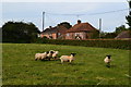
7
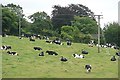
Footpath through the cows
Some people would be nervous about following this path, but dairy cows are generally placid and ignore you, or get up and walk away.
Image: © Graham Horn
Taken: 16 Aug 2008
0.19 miles
8
The Common, Red Lane
Nearing the southern end of the byway from East Winterslow; properties and their cars approaching.
Image: © Mike Faherty
Taken: 7 Dec 2013
0.21 miles
9
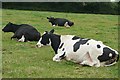
Cattle on the footpath
OK just walk around us, we're contented here thanks.
Image: © Graham Horn
Taken: 16 Aug 2008
0.22 miles
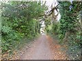
10
View south west from Mill Lane
Mill Lane connects the hamlet of East Winterslow with the larger village of Middle Winterslow, which can just be seen on the horizon.
Image: © Peter Jordan
Taken: 23 Jun 2006
0.25 miles