IMAGES TAKEN NEAR TO
West Dean, SALISBURY, SP5 1JN
Introduction
This page details the photographs taken nearby to SP5 1JN by members of the Geograph project.
The Geograph project started in 2005 with the aim of publishing, organising and preserving representative images for every square kilometre of Great Britain, Ireland and the Isle of Man.

There are currently over 7.5m images from over14,400 individuals and you can help contribute to the project by visiting https://www.geograph.org.uk
Image Map (Loading...)


Getting Data...Please wait
Leaflet Map data © OpenStreetMap
Images are licensed for reuse under creativecommons.org/licenses/by-sa/2.0
Notes
- Clicking on the map will re-center to the selected point.
- The higher the marker number, the further away the image location is from the centre of the postcode.
Image Listing (4 Images Found)
Images are licensed for reuse under creativecommons.org/licenses/by-sa/2.0
Image
Details
Distance
1
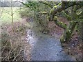
Stream, West Dean
There a number of springs and streams in the area all running into the River Dun.
Image: © Maigheach-gheal
Taken: 25 Jan 2010
0.13 miles
2
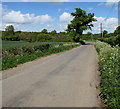
Dean Road towards West Tytherley
Dean Road heads away from the village of West Dean in south Wiltshire.
Image: © Jaggery
Taken: 9 May 2015
0.19 miles
3
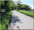
Northern boundary of West Dean, Wiltshire
West Dean is a small village in Wiltshire, near the Hampshire border.
Image: © Jaggery
Taken: 9 May 2015
0.24 miles
4
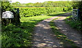
Entrance to Woodside Farm, West Dean
Near the northern boundary http://www.geograph.org.uk/photo/4468326 of the village. The name sign shows Woodside Farm CONNEMARA STUD.
Image: © Jaggery
Taken: 9 May 2015
0.25 miles