IMAGES TAKEN NEAR TO
West Dean, SALISBURY, SP5 1HW
Introduction
This page details the photographs taken nearby to SP5 1HW by members of the Geograph project.
The Geograph project started in 2005 with the aim of publishing, organising and preserving representative images for every square kilometre of Great Britain, Ireland and the Isle of Man.

There are currently over 7.5m images from over14,400 individuals and you can help contribute to the project by visiting https://www.geograph.org.uk
Image Map
Images are licensed for reuse under creativecommons.org/licenses/by-sa/2.0
Notes
- Clicking on the map will re-center to the selected point.
- The higher the marker number, the further away the image location is from the centre of the postcode.
Image Listing (8 Images Found)
Images are licensed for reuse under creativecommons.org/licenses/by-sa/2.0
Image
Details
Distance
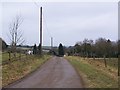
2
Rough grazing, Dean Hill Farm
An area of rough grazing. The weather radar mast does not appear on the map and is in the next square.
Image: © Maigheach-gheal
Taken: 18 Nov 2008
0.08 miles
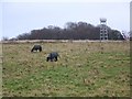
3
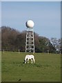
White pony and weather radar
The radar mast is about 500m beyond the pony, grazing near Dean Hill Farm.
Image: © David Martin
Taken: 25 Mar 2012
0.09 miles
4
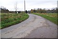
Drive to Dean Hill Farm
The byway now becomes metalled.
Image: © Maigheach-gheal
Taken: 18 Nov 2008
0.13 miles
5
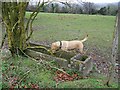
Old trough near Dean Hill Farm
Ben looks in the empty trough - the bottom was cracked and he was disappointed. The paddocks appeared to be over grazed.
Image: © Maigheach-gheal
Taken: 18 Nov 2008
0.14 miles
6
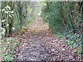
Byway near Dean Hill Farm
As the byway nears Dean Hill Farm it becomes hedged.
Image: © Maigheach-gheal
Taken: 18 Nov 2008
0.16 miles
7
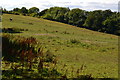
Sloping field near the summit of Dean Hill
Image: © David Martin
Taken: 6 Aug 2020
0.17 miles
8
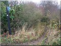
Bridleway to West Dean Farm
The bridleway drops steeply down towards the farm buildings at West Dean Farm.
Image: © Maigheach-gheal
Taken: 18 Nov 2008
0.17 miles