IMAGES TAKEN NEAR TO
West Dean, SALISBURY, SP5 1EZ
Introduction
This page details the photographs taken nearby to SP5 1EZ by members of the Geograph project.
The Geograph project started in 2005 with the aim of publishing, organising and preserving representative images for every square kilometre of Great Britain, Ireland and the Isle of Man.

There are currently over 7.5m images from over14,400 individuals and you can help contribute to the project by visiting https://www.geograph.org.uk
Image Map
Images are licensed for reuse under creativecommons.org/licenses/by-sa/2.0
Notes
- Clicking on the map will re-center to the selected point.
- The higher the marker number, the further away the image location is from the centre of the postcode.
Image Listing (6 Images Found)
Images are licensed for reuse under creativecommons.org/licenses/by-sa/2.0
Image
Details
Distance
1
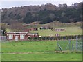
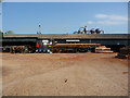
Dean Hill Park - view towards gatehouse
This was once Royal Naval Armaments Depot Dean Hill, closed in 2004 and now a business park. In military use the site boasted a mainline railway connection and its own narrow gauge internal rail network: it was used for the maintenance of naval weapons and featured various workshop buildings and underground storage magazines in the side of the hill.
Image: © David Martin
Taken: 4 Dec 2011
0.05 miles
4
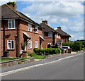
Hillside Close houses, West Dean
In the Hampshire part of the village, most of which is in Wiltshire.
Image: © Jaggery
Taken: 9 May 2015
0.24 miles
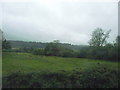
5
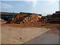
West Dean - East Brothers Sawmill
Established in West Dean in 1886 East Brothers have three sawmill lines and an extensive stock yard.
Image: © Chris Talbot
Taken: 2 May 2011
0.25 miles
6
West Dean - East Brothers Sawmill
Established in West Dean in 1886 East Brothers have three sawmill lines and an extensive stock yard.
Image: © Chris Talbot
Taken: 2 May 2011
0.25 miles