IMAGES TAKEN NEAR TO
West Dean, SALISBURY, SP5 1EY
Introduction
This page details the photographs taken nearby to SP5 1EY by members of the Geograph project.
The Geograph project started in 2005 with the aim of publishing, organising and preserving representative images for every square kilometre of Great Britain, Ireland and the Isle of Man.

There are currently over 7.5m images from over14,400 individuals and you can help contribute to the project by visiting https://www.geograph.org.uk
Image Map (Loading...)


Getting Data...Please wait
Leaflet Map data © OpenStreetMap
Images are licensed for reuse under creativecommons.org/licenses/by-sa/2.0
Notes
- Clicking on the map will re-center to the selected point.
- The higher the marker number, the further away the image location is from the centre of the postcode.
Image Listing (7 Images Found)
Images are licensed for reuse under creativecommons.org/licenses/by-sa/2.0
Image
Details
Distance
2
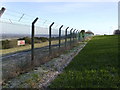
Fence around MOD depot
The fence along south side of the old MOD depot running along the top of Dean Hill.
Image: © Patrick Pavey
Taken: 25 Jan 2007
0.19 miles

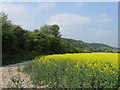
5
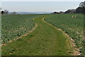
Arable crop west of Dean Lane
The cruciferous crop is just coming into flower and could be oil-seed-rape.
Image: © Stuart Logan
Taken: 25 Apr 2013
0.25 miles
7
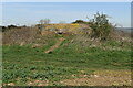
Pill box on Dean Hill
One of a line of defences on Dean Hill above the former Royal Navy Armaments Depot.
Image: © David Martin
Taken: 30 Mar 2021
0.25 miles