IMAGES TAKEN NEAR TO
Pitton, SALISBURY, SP5 1EW
Introduction
This page details the photographs taken nearby to SP5 1EW by members of the Geograph project.
The Geograph project started in 2005 with the aim of publishing, organising and preserving representative images for every square kilometre of Great Britain, Ireland and the Isle of Man.

There are currently over 7.5m images from over14,400 individuals and you can help contribute to the project by visiting https://www.geograph.org.uk
Image Map (Loading...)


Getting Data...Please wait
Leaflet Map data © OpenStreetMap
Images are licensed for reuse under creativecommons.org/licenses/by-sa/2.0
Notes
- Clicking on the map will re-center to the selected point.
- The higher the marker number, the further away the image location is from the centre of the postcode.
Image Listing (6 Images Found)
Images are licensed for reuse under creativecommons.org/licenses/by-sa/2.0
Image
Details
Distance
2
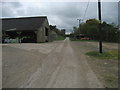
Track at Four Cottages
Access track leading north from Four Cottages, by Pitton Copse.
Image: © Chris Heaton
Taken: 9 May 2010
0.08 miles
3
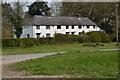
Four Cottages
The hamlet is known as four cottages. It consists of farm buildings and a row of estate workers' cottages. Seen from the edge of the woodland to the west.
Image: © Graham Horn
Taken: 16 Aug 2008
0.10 miles
4
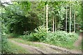
Tracks in Pitton Copse
There are many tracks through the copse but only one public footpath.
Image: © Graham Horn
Taken: 16 Aug 2008
0.16 miles
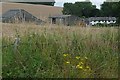
5
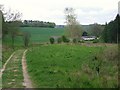
Leaving Carverel Copse on the Clarendon Way
The Way exits the wooded slopes of King Manor Hill, heading towards 'Four Cottages' (white buildings on right)
Image: © Tim Heaton
Taken: 9 May 2010
0.20 miles
6
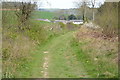
On the Clarendon Way, looking back towards Four Cottages
Image: © David Martin
Taken: 15 Apr 2019
0.20 miles