IMAGES TAKEN NEAR TO
The Hanging, SALISBURY, SP5 1ES
Introduction
This page details the photographs taken nearby to The Hanging, SP5 1ES by members of the Geograph project.
The Geograph project started in 2005 with the aim of publishing, organising and preserving representative images for every square kilometre of Great Britain, Ireland and the Isle of Man.

There are currently over 7.5m images from over14,400 individuals and you can help contribute to the project by visiting https://www.geograph.org.uk
Image Map
Images are licensed for reuse under creativecommons.org/licenses/by-sa/2.0
Notes
- Clicking on the map will re-center to the selected point.
- The higher the marker number, the further away the image location is from the centre of the postcode.
Image Listing (5 Images Found)
Images are licensed for reuse under creativecommons.org/licenses/by-sa/2.0
Image
Details
Distance
1
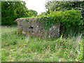
East Dean - Pillbox
One of a line of pillboxes that were to defend the Royal Navy Armaments Depot Dean Hill in case of German invasion during WW2.
Image: © Chris Talbot
Taken: 2 May 2011
0.13 miles
2
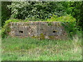
East Dean - Pillbox
One of a line of pillboxes that were to defend the Royal Navy Armaments Depot Dean Hill in case of German invasion during WW2.
Image: © Chris Talbot
Taken: 2 May 2011
0.13 miles
3
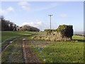
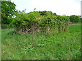
Disused Gun Emplacement
One of a line of gun emplacements along the top of Dean Hill near the Hampshire/Wiltshire border. These had strategic importance for the defence of the MOD munitions depot on the north side of the hill.
Image: © Patrick Pavey
Taken: 25 Jan 2007
0.16 miles
4
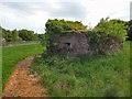
East Dean - Pillbox
One of a line of pillboxes that were to defend the Royal Navy Armaments Depot Dean Hill in case of German invasion during WW2.
Image: © Chris Talbot
Taken: 2 May 2011
0.22 miles
5
East Dean - Pillbox
One of a line of pillboxes that were to defend the Royal Navy Armaments Depot Dean Hill in case of German invasion during WW2.
Image: © Chris Talbot
Taken: 2 May 2011
0.22 miles