IMAGES TAKEN NEAR TO
Clarendon Park, SALISBURY, SP5 1EP
Introduction
This page details the photographs taken nearby to Clarendon Park, SP5 1EP by members of the Geograph project.
The Geograph project started in 2005 with the aim of publishing, organising and preserving representative images for every square kilometre of Great Britain, Ireland and the Isle of Man.

There are currently over 7.5m images from over14,400 individuals and you can help contribute to the project by visiting https://www.geograph.org.uk
Image Map (Loading...)


Getting Data...Please wait
Leaflet Map data © OpenStreetMap
Images are licensed for reuse under creativecommons.org/licenses/by-sa/2.0
Notes
- Clicking on the map will re-center to the selected point.
- The higher the marker number, the further away the image location is from the centre of the postcode.
Image Listing (7 Images Found)
Images are licensed for reuse under creativecommons.org/licenses/by-sa/2.0
Image
Details
Distance
1
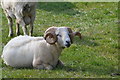
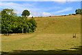
Downland, Pitton
The building below is at White House on the lane south of Pitton. The house itself is hidden by trees.
Image: © Andrew Smith
Taken: 1 Jul 2007
0.10 miles
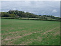
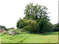
3
Footpath up steep valley side near Pitton
Image: © David Martin
Taken: 30 Aug 2013
0.18 miles
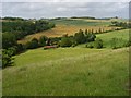
4
Memorial seats, Pitton
Two conveniently placed seats by the footpath overlooking Clarendon Woods.
Image: © Maigheach-gheal
Taken: 25 Sep 2008
0.21 miles
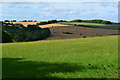
5
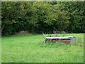
Hay rack near Pitton
This hay rack looks as if it is still holding last year's hay. The pasture has been fairly recently mown.
Image: © Maigheach-gheal
Taken: 25 Sep 2008
0.21 miles