IMAGES TAKEN NEAR TO
White Way, SALISBURY, SP5 1DT
Introduction
This page details the photographs taken nearby to White Way, SP5 1DT by members of the Geograph project.
The Geograph project started in 2005 with the aim of publishing, organising and preserving representative images for every square kilometre of Great Britain, Ireland and the Isle of Man.

There are currently over 7.5m images from over14,400 individuals and you can help contribute to the project by visiting https://www.geograph.org.uk
Image Map (Loading...)


Getting Data...Please wait
Leaflet Map data © OpenStreetMap
Images are licensed for reuse under creativecommons.org/licenses/by-sa/2.0
Notes
- Clicking on the map will re-center to the selected point.
- The higher the marker number, the further away the image location is from the centre of the postcode.
Image Listing (88 Images Found)
Images are licensed for reuse under creativecommons.org/licenses/by-sa/2.0
Image
Details
Distance
1
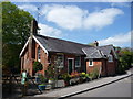
Pitton - The Old School House
This used to be the school house for Pitton but is now a private dwelling
Image: © Chris Talbot
Taken: 2 May 2009
0.02 miles
2
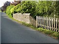
Whiteway Bridge, Pitton
There is a cut benchmark on this road bridge. For a closer view of the benchmark visit https://www.geograph.org.uk/photo/6477080
Image: © Walking Moonraker
Taken: 17 May 2020
0.05 miles
3
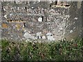
Cut Benchmark White Way Bridge
Ordnance Survey Cut Benchmark on brick bridge, White Way Pitton. For a wider view of the bridge visit https://www.geograph.org.uk/photo/6497237
Image: © Walking Moonraker
Taken: 17 May 2020
0.05 miles
4
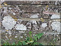
Bench Mark, White Way Bridge, Pitton
The cut mark is to be found on the parapet of a bridge over a very deep ditch in the centre of the village. For more information about the mark http://www.bench-marks.org.uk/bm35008
A bench mark is an Ordnance Survey arrowhead sign found on walls, bridges, churches and specially erected triangulation pillars where the altitude above sea-level has been accurately measured by surveyors. The arrowhead points to a horizontal line above it which marks the exact altitude.
With rivets and pivots there is no datum (horizontal line) cut, the pointed-to horizontal surface defining the datum height.
Image: © Maigheach-gheal
Taken: 31 Jul 2010
0.05 miles
5
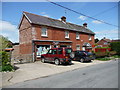
Pitton - Post Office
Pitton's Post Office and village store.
Image: © Chris Talbot
Taken: 2 May 2009
0.06 miles
6
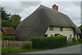
Thatched cottage, Pitton
One of many thatched buildings in this attractive village.
Image: © Graham Horn
Taken: 16 Aug 2008
0.06 miles
7
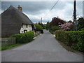
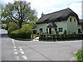
Entering Pitton
Entering Pitton by a lovely thatched cottage on High Street - adopted by the Clarendon Way.
Image: © Chris Heaton
Taken: 9 May 2010
0.07 miles
8
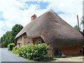
Thatched cottage, Pitton
One of the many thatched cottages in the village.
Image: © Maigheach-gheal
Taken: 6 Jul 2008
0.08 miles
9
Pitton - Road Junction
The junction of White Way and Slate Way.
Image: © Chris Talbot
Taken: 2 May 2009
0.08 miles
10
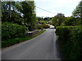
Pitton - White Way
Looking up White Way towards the Silver Plough.
Image: © Chris Talbot
Taken: 2 May 2009
0.08 miles