IMAGES TAKEN NEAR TO
Black Lane, SALISBURY, SP5 1DR
Introduction
This page details the photographs taken nearby to Black Lane, SP5 1DR by members of the Geograph project.
The Geograph project started in 2005 with the aim of publishing, organising and preserving representative images for every square kilometre of Great Britain, Ireland and the Isle of Man.

There are currently over 7.5m images from over14,400 individuals and you can help contribute to the project by visiting https://www.geograph.org.uk
Image Map
Images are licensed for reuse under creativecommons.org/licenses/by-sa/2.0
Notes
- Clicking on the map will re-center to the selected point.
- The higher the marker number, the further away the image location is from the centre of the postcode.
Image Listing (84 Images Found)
Images are licensed for reuse under creativecommons.org/licenses/by-sa/2.0
Image
Details
Distance
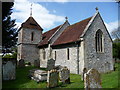
1
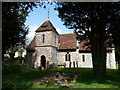
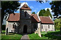
Pitton - St Peters Church
Pretty country church of flint and brick construction.
Image: © Chris Talbot
Taken: 2 May 2009
0.00 miles
2
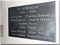
Pitton - War Memorial
This slate plaque commemorating the men of Pitton who died in two world wars can be found inside St Peters Church.
Image: © Chris Talbot
Taken: 2 May 2009
0.00 miles
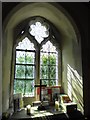
3
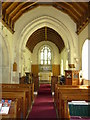
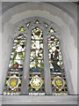
Pitton - St Peter's Church
Looking towards the altar of St Peter's.
Image: © Chris Talbot
Taken: 2 May 2009
0.00 miles
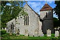
4
Pitton - St Peters Church
A typical flint and brick built village church.
Image: © Chris Talbot
Taken: 2 May 2009
0.00 miles
5
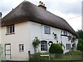
Coldharbour Farm, Pitton
Charming thatched farmhouse on the High Street.
Image: © Maigheach-gheal
Taken: 6 Jul 2008
0.04 miles