IMAGES TAKEN NEAR TO
Fittleton, SALISBURY, SP4 9PZ
Introduction
This page details the photographs taken nearby to SP4 9PZ by members of the Geograph project.
The Geograph project started in 2005 with the aim of publishing, organising and preserving representative images for every square kilometre of Great Britain, Ireland and the Isle of Man.

There are currently over 7.5m images from over14,400 individuals and you can help contribute to the project by visiting https://www.geograph.org.uk
Image Map
Images are licensed for reuse under creativecommons.org/licenses/by-sa/2.0
Notes
- Clicking on the map will re-center to the selected point.
- The higher the marker number, the further away the image location is from the centre of the postcode.
Image Listing (47 Images Found)
Images are licensed for reuse under creativecommons.org/licenses/by-sa/2.0
Image
Details
Distance
1
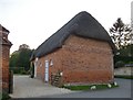
Tithe barn at Fittleton Manor, seen from the east
Whereas the north-facing side of this building has exposed timber framing http://www.geograph.org.uk/photo/4954804 the south side is plainly of much later construction. The lunette windows suggest an 18th-century date. The original barn doors have been replaced by typical stable half-doors - all of which suggests that the medieval barn was converted to stables in Georgian times.
Image: © Stefan Czapski
Taken: 16 May 2016
0.03 miles
2
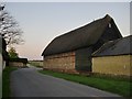
Tithe barn at Fittleton Manor: northern aspect
Situated along the northern boundary of the manor house grounds.
When I first captioned this image I described the barn as a 'thatched out-building'. Though it seemed to be a medieval barn, I was puzzled by the narrow doorways on the other (inward-facing) side - stable half-doors, Since then, I have found that the building is generally referred to as a tithe barn.
Plainly the south-facing wall of the building is later http://www.geograph.org.uk/photo/4957908 - the half-moon windows look Georgian - so my guess is that the barn was converted to stables at some stage in the 18th century.
In any case, it's a handsome building, reminding me of Cressing Temple (in a different part of England altogether): http://www.geograph.org.uk/photo/4618556
Image: © Stefan Czapski
Taken: 16 May 2016
0.03 miles
3
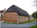
Tithe barn at Fittleton Manor, from the north-east
The exposed timber framing (with brick 'nogging') along the north side of the barn contrasts with the rather more modern brickwork of the east-facing wall.
The manor house itself - brick and flint - can be glimpsed through the opening on the left.
Image: © Stefan Czapski
Taken: 16 May 2016
0.04 miles
4
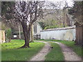
Approach to All Saints Church, Fittleton
Grassy approach beneath trees to the church. The cob wall borders Fittleton Manor and a blackbird and spring blossom add to the picture.
Image: © Maigheach-gheal
Taken: 11 Mar 2007
0.04 miles
5
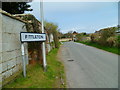
The Orange Way in Wiltshire (277)
Fittleton is reached.
Image: © Shazz
Taken: 25 Apr 2013
0.05 miles
6
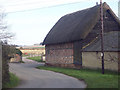
Barn, Haxton
16th Century timber framed barn with brick noggin.
Image: © Maigheach-gheal
Taken: 11 Mar 2007
0.05 miles
7
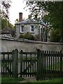
The Rectory, Fittleton
Vast. The rector of Fittleton must have lived like a sultan.
Seen from the churchyard gate.
Image: © Stefan Czapski
Taken: 16 May 2016
0.05 miles
8
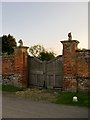
Gateway at Fittleton Manor
No longer used, but this must once have been the grand entrance to the manor house.
Image: © Stefan Czapski
Taken: 16 May 2016
0.06 miles
9
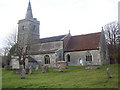
The Church of All Saints, Fittleton
Recorded in 1086 Fittleton was named 'Viteltone'.
Image: © Maigheach-gheal
Taken: 11 Mar 2007
0.07 miles
10
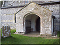
All Saints Church, Fittleton - Porch
Image: © Maigheach-gheal
Taken: 11 Mar 2007
0.07 miles