IMAGES TAKEN NEAR TO
James Road, SALISBURY, SP4 7PZ
Introduction
This page details the photographs taken nearby to James Road, SP4 7PZ by members of the Geograph project.
The Geograph project started in 2005 with the aim of publishing, organising and preserving representative images for every square kilometre of Great Britain, Ireland and the Isle of Man.

There are currently over 7.5m images from over14,400 individuals and you can help contribute to the project by visiting https://www.geograph.org.uk
Image Map
Images are licensed for reuse under creativecommons.org/licenses/by-sa/2.0
Notes
- Clicking on the map will re-center to the selected point.
- The higher the marker number, the further away the image location is from the centre of the postcode.
Image Listing (7 Images Found)
Images are licensed for reuse under creativecommons.org/licenses/by-sa/2.0
Image
Details
Distance
1
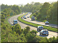
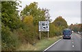
The A303, Amesbury
Descending to the crossing of the River Avon. Viewed from the bridge on the Bulford Road.
Image: © Andrew Smith
Taken: 18 May 2008
0.15 miles
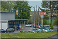
2
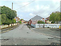
Amesbury : Beacon Close
From London Road.
Image: © Lewis Clarke
Taken: 27 Apr 2019
0.19 miles
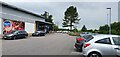
6
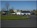
Amesbury : Lidl
Looking towards the Lidl store.
Image: © Lewis Clarke
Taken: 27 Apr 2019
0.23 miles