IMAGES TAKEN NEAR TO
Holders Road, SALISBURY, SP4 7PH
Introduction
This page details the photographs taken nearby to Holders Road, SP4 7PH by members of the Geograph project.
The Geograph project started in 2005 with the aim of publishing, organising and preserving representative images for every square kilometre of Great Britain, Ireland and the Isle of Man.

There are currently over 7.5m images from over14,400 individuals and you can help contribute to the project by visiting https://www.geograph.org.uk
Image Map (Loading...)


Getting Data...Please wait
Leaflet Map data © OpenStreetMap
Images are licensed for reuse under creativecommons.org/licenses/by-sa/2.0
Notes
- Clicking on the map will re-center to the selected point.
- The higher the marker number, the further away the image location is from the centre of the postcode.
Image Listing (3 Images Found)
Images are licensed for reuse under creativecommons.org/licenses/by-sa/2.0
Image
Details
Distance
1
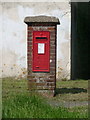
Amesbury: postbox № SP4 145, Devereux Road
This George V-reign postbox is set into a brick pillar on a grassy plot on the corner of Coltsfoot Close. Until fairly recently, it had a phone box for company but that has been removed.
Image: © Chris Downer
Taken: 19 Jun 2014
0.18 miles
3

Co-op convenience shop on Beaulieu Road
Image: © Roger Cornfoot
Taken: 14 Jun 2024
0.21 miles