IMAGES TAKEN NEAR TO
Lake, SALISBURY, SP4 7BP

Introduction

This page details the photographs taken nearby to SP4 7BP by members of the Geograph project.

The Geograph project started in 2005 with the aim of publishing, organising and preserving representative images for every square kilometre of Great Britain, Ireland and the Isle of Man.

There are currently over 7.5m images from over14,400 individuals and you can help contribute to the project by visiting https://www.geograph.org.uk

Image Map


Images are licensed for reuse under creativecommons.org/licenses/by-sa/2.0
Notes
  • Clicking on the map will re-center to the selected point.
  • The higher the marker number, the further away the image location is from the centre of the postcode.

Image Listing (18 Images Found)

Images are licensed for reuse under creativecommons.org/licenses/by-sa/2.0
Image
Details
Distance
1
Houses at Lake
Past the thatched former post office on the immediate left is a glimpse of the listed Fir Tree Cottage https://www.historicengland.org.uk/listing/the-list/list-entry/1131000 , originally an "estate dwelling and workshop". Next come Diamond Cottages, a terrace of 4.
Image: © Derek Harper Taken: 17 Jul 2016
0.01 miles
2
Bus shelter and telephone box at Lake
K6 type telephone box near the village centre.
Image: © Maigheach-gheal Taken: 12 Feb 2007
0.01 miles
3
Lake Village
Image: © Anthony Parkes Taken: 1 Jun 2023
0.01 miles
4
Junction, Lake
The telephone box, bus shelter, bus stop and postbox all appear in Image The thatched cottage up the road is the former post office.
Image: © Derek Harper Taken: 17 Jul 2016
0.02 miles
5
Postbox, Lake
A close view of the Elizabeth II postbox shown in Image The number is SP4 195.
Image: © Derek Harper Taken: 17 Jul 2016
0.03 miles
6
Approaching Lake
Looking in the other direction from the same spot as Image
Image: © Derek Harper Taken: 17 Jul 2016
0.06 miles
7
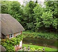
Mill pond at Lake
A linear mill pond, named as such on the maps, but really a channel leading to the former mill and its sluices. A narrow band of woodland separates it from the river beyond. Viewed looking past a thatched cottage from the lane through the hamlet.
Image: © Derek Harper Taken: 17 Jul 2016
0.06 miles
8
Club House at Lake
Image: © Maigheach-gheal Taken: 12 Feb 2007
0.09 miles
9
View over Lake
Wilsford Church can be clearly seen in the middle distance.
Image: © David Martin Taken: 29 Aug 2021
0.09 miles
10
Lake House
Elizabethan house dating from 1578, Grade I listed building in Grade II listed grounds. For designation, see https://historicengland.org.uk/listing/the-list/list-entry/1001237. Seen here from the footpath descending the adjacent hill.
Image: © David Martin Taken: 29 Aug 2021
0.09 miles