IMAGES TAKEN NEAR TO
Normanton, Amesbury, SALISBURY, SP4 7BJ
Introduction
This page details the photographs taken nearby to SP4 7BJ by members of the Geograph project.
The Geograph project started in 2005 with the aim of publishing, organising and preserving representative images for every square kilometre of Great Britain, Ireland and the Isle of Man.

There are currently over 7.5m images from over14,400 individuals and you can help contribute to the project by visiting https://www.geograph.org.uk
Image Map
Images are licensed for reuse under creativecommons.org/licenses/by-sa/2.0
Notes
- Clicking on the map will re-center to the selected point.
- The higher the marker number, the further away the image location is from the centre of the postcode.
Image Listing (14 Images Found)
Images are licensed for reuse under creativecommons.org/licenses/by-sa/2.0
Image
Details
Distance
1
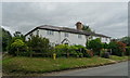
Houses on National Cycle Route 45, Normanton
Image: © JThomas
Taken: 13 Jul 2019
0.00 miles
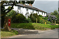
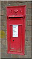
4
Postbox, Normanton
An Edward VII reign postbox in the Woodford Valley.
Image: © Maigheach-gheal
Taken: 1 Jan 2011
0.01 miles
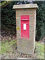
5
Edward VII postbox, Normanton
Postbox No. SP4 151.
See Image] for context.
Image: © JThomas
Taken: 13 Jul 2019
0.01 miles
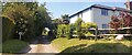
6
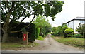
Track off National Cycle Route 45, Normanton
Showing position of Postbox No. SP4 151.
See Image] for postbox.
Image: © JThomas
Taken: 13 Jul 2019
0.02 miles
7
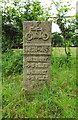
Milestone on National Cycle Route 45, Normanton
Salisbury 8 Miles / Amesbury 2 Miles.
Image: © JThomas
Taken: 13 Jul 2019
0.03 miles
8
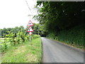
National Cycle Route 45, Normanton
Towards Salisbury.
Image: © JThomas
Taken: 13 Jul 2019
0.06 miles
9
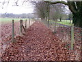
Footpath, Normanton
The path takes walkers towards the River Avon and once across the river onwards to Amesbury Down.
Image: © Maigheach-gheal
Taken: 1 Jan 2011
0.07 miles
10

Crop field, Normanton
Off National Cycle Route 45.
Image: © JThomas
Taken: 13 Jul 2019
0.07 miles