IMAGES TAKEN NEAR TO
Middle Woodford, SALISBURY, SP4 6NW
Introduction
This page details the photographs taken nearby to SP4 6NW by members of the Geograph project.
The Geograph project started in 2005 with the aim of publishing, organising and preserving representative images for every square kilometre of Great Britain, Ireland and the Isle of Man.

There are currently over 7.5m images from over14,400 individuals and you can help contribute to the project by visiting https://www.geograph.org.uk
Image Map
Images are licensed for reuse under creativecommons.org/licenses/by-sa/2.0
Notes
- Clicking on the map will re-center to the selected point.
- The higher the marker number, the further away the image location is from the centre of the postcode.
Image Listing (93 Images Found)
Images are licensed for reuse under creativecommons.org/licenses/by-sa/2.0
Image
Details
Distance
1
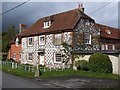
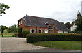
Limestone, flint and brick house at Middle Woodford
The limestone and flint chequered construction is an attractive characteristic of this area.
Image: © David Martin
Taken: 22 Apr 2012
0.02 miles
2

Woodford Mill
A reverse view of Image]; https://www.historicengland.org.uk/listing/the-list/list-entry/1318528 , with the Monarch's Way heading towards Lower Woodford.
Image: © Derek Harper
Taken: 17 Jul 2016
0.02 miles
3

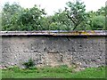
Woodford Mill
Much of the property, including the actual former mill building, is across a grid line in Image, but this main part facing the road, together with the extension beyond, is in square. It features attractive chequerwork. See also Image - note that the blind window referred to in the listed building description https://www.historicengland.org.uk/listing/the-list/list-entry/1318528 , at upper right, has now been replaced to match the other sixteen-paned sashes. On the immediate right is the wall shown at http://www.geograph.org.uk/search.php?i=67378765 . The Monarch's Way follows the road into Middle Woodford.
Image: © Derek Harper
Taken: 17 Jul 2016
0.03 miles
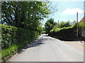
4

Road past Beauchamp House
Carrying the Monarch's Way as it heads south from Middle Woodford, and approaching Woodford Mill.
Image: © Derek Harper
Taken: 17 Jul 2016
0.03 miles
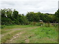
7
Field entrance and farm building, Middle Woodford
Image: © JThomas
Taken: 13 Jul 2019
0.04 miles
9
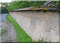
Woodford Mill Garden Wall
A traditional cob wall surrounding this riverside garden. See Image
Image: © Nigel Mykura
Taken: 24 Aug 2011
0.05 miles
10
Woodford Mill Garden Wall
This cob wall surrounds part of the garden of the mill. Cob is basically dried clay mixed with other materials. This cob contains a large proportion of flint fragments between 5mm and 50mm. There appeared to be only a small amount of straw. The cob had obviously been laid in courses. This was traditionally done by trampling one course, waiting for it to dry and then laying the next one. Each course appeared to be about 450mm high. The top of the wall was tiled to protect the cob from damp. Some decay of the wall had already taken place due to damp penetration although this was only slight and generally the wall is in good condition.
The garden is on the bank of the Avon which would have been a good source of the clay. The flints would have been natural as a result of washing out of the local upland chalk into the river valley clays.
One third of the world population live in cob built structures
Image: © Nigel Mykura
Taken: 24 Aug 2011
0.05 miles