IMAGES TAKEN NEAR TO
Church Lane, SALISBURY, SP4 6NP
Introduction
This page details the photographs taken nearby to Church Lane, SP4 6NP by members of the Geograph project.
The Geograph project started in 2005 with the aim of publishing, organising and preserving representative images for every square kilometre of Great Britain, Ireland and the Isle of Man.

There are currently over 7.5m images from over14,400 individuals and you can help contribute to the project by visiting https://www.geograph.org.uk
Image Map (91 Images)


Getting Data...Please wait
Leaflet Map data © OpenStreetMap
Images are licensed for reuse under creativecommons.org/licenses/by-sa/2.0
Notes
- Clicking on the map will re-center to the selected point.
- The higher the marker number, the further away the image location is from the centre of the postcode.
Image Listing (91 Images Found)
Images are licensed for reuse under creativecommons.org/licenses/by-sa/2.0
Image
Details
Distance
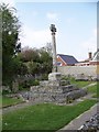
1
Lane near All Saints Church, Middle Woodford
Image: © JThomas
Taken: 13 Jul 2019
0.01 miles
2
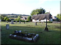
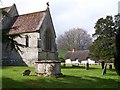
All Saints, Middle Woodford: churchyard (II)
Image: © Basher Eyre
Taken: 19 Aug 2016
0.01 miles
3

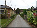
Church Lane, Middle Woodford
Houses on a little back lane that runs behind the church.
Image: © Derek Harper
Taken: 17 Jul 2016
0.01 miles
4
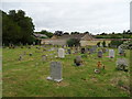
Graveyard, All Saints Church, Middle Woodford
Image: © JThomas
Taken: 13 Jul 2019
0.02 miles
6
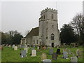
All Saints Church at Middle Woodford
Viewed from the north-west.
Image: © Peter Wood
Taken: 12 Feb 2017
0.03 miles
9
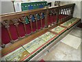
All Saints, Middle Woodford: altar rail
Image: © Basher Eyre
Taken: 10 Sep 2024
0.04 miles