IMAGES TAKEN NEAR TO
Grouse Road, SALISBURY, SP4 6GE
Introduction
This page details the photographs taken nearby to Grouse Road, SP4 6GE by members of the Geograph project.
The Geograph project started in 2005 with the aim of publishing, organising and preserving representative images for every square kilometre of Great Britain, Ireland and the Isle of Man.

There are currently over 7.5m images from over14,400 individuals and you can help contribute to the project by visiting https://www.geograph.org.uk
Image Map
Images are licensed for reuse under creativecommons.org/licenses/by-sa/2.0
Notes
- Clicking on the map will re-center to the selected point.
- The higher the marker number, the further away the image location is from the centre of the postcode.
Image Listing (17 Images Found)
Images are licensed for reuse under creativecommons.org/licenses/by-sa/2.0
Image
Details
Distance
1
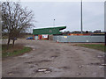
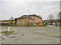
Salisbury City Football Club Stadium
Image: © Maigheach-gheal
Taken: 13 Feb 2007
0.08 miles
2
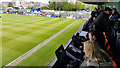
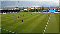
Salisbury : Raymond McEnhill Stadium
The Raymond McEnhill Stadium is a purpose built 5,000 capacity football stadium in Salisbury and home of Salisbury FC. Here were are in the press box before the playoff final of the Southern League South & West.
Image: © Lewis Clarke
Taken: 1 May 2017
0.10 miles
3
Salisbury : Raymond McEnhill Stadium
The Raymond McEnhill Stadium is a purpose built 5,000 capacity football stadium in Salisbury and home of Salisbury FC.
Image: © Lewis Clarke
Taken: 1 May 2017
0.10 miles
4
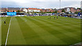
Salisbury : Raymond McEnhill Stadium
The Raymond McEnhill Stadium is a purpose built 5,000 capacity football stadium in Salisbury and home of Salisbury FC.
Image: © Lewis Clarke
Taken: 1 May 2017
0.11 miles
5
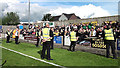
Salisbury : Raymond McEnhill Stadium
Tiverton Town supporters celebrating their win in the playoff final with some security guards making sure they don't get onto the pitch.
Image: © Lewis Clarke
Taken: 1 May 2017
0.14 miles
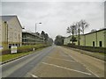
6
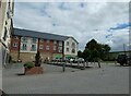
Wandering westwards along the Bashire (73)
Old Sarum Co-Op
Image: © Basher Eyre
Taken: 13 Aug 2023
0.18 miles
7
Old Sarum, Army Reserve Centre
On The Portway; home to units of the Royal Wessex Yeomanry. http://www.army.mod.uk/join/32575.aspx
Image: © Mike Faherty
Taken: 6 Feb 2017
0.19 miles
8
Old Sarum, The Portway
Former Roman road from Old Sarum to Silchester. The area is now subject to residential and commercial redevelopment. http://penelope.uchicago.edu/Thayer/E/Gazetteer/Periods/Roman/Topics/Engineering/roads/Britain/_Texts/CODROM/9*.html#4
Image: © Mike Faherty
Taken: 6 Feb 2017
0.20 miles