IMAGES TAKEN NEAR TO
Great Durnford, SALISBURY, SP4 6BD
Introduction
This page details the photographs taken nearby to SP4 6BD by members of the Geograph project.
The Geograph project started in 2005 with the aim of publishing, organising and preserving representative images for every square kilometre of Great Britain, Ireland and the Isle of Man.

There are currently over 7.5m images from over14,400 individuals and you can help contribute to the project by visiting https://www.geograph.org.uk
Image Map
Images are licensed for reuse under creativecommons.org/licenses/by-sa/2.0
Notes
- Clicking on the map will re-center to the selected point.
- The higher the marker number, the further away the image location is from the centre of the postcode.
Image Listing (9 Images Found)
Images are licensed for reuse under creativecommons.org/licenses/by-sa/2.0
Image
Details
Distance
1
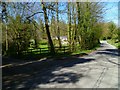
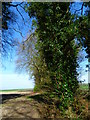
The Orange Way in Wiltshire (213)
Passing the drive to Great Durnford Manor, Fairwood House is visible through the trees.
Image: © Shazz
Taken: 23 Apr 2013
0.01 miles
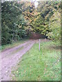
2
The Orange Way in Wiltshire (214)
This bridleway is taken on the edge of Ham Wood.
Image: © Shazz
Taken: 23 Apr 2013
0.03 miles
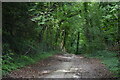
6
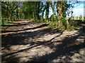
The Orange Way in Wiltshire (215)
The bridleway through the woods continues upwards.
Image: © Shazz
Taken: 23 Apr 2013
0.19 miles
7
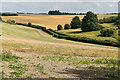
Farmland, Great Durnford
On a footpath in the middle of Ogbury, a hill-fort, looking ahead to Catsbrain, the plantation.
Image: © Andrew Smith
Taken: 5 Aug 2007
0.19 miles
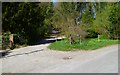
8
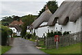
Thatched cottages on The Drive, Great Durnford
A private road leading to Great Durnford Manor.
Image: © David Martin
Taken: 29 Aug 2021
0.23 miles
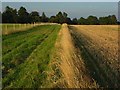
9
The Orange Way in Wiltshire (216)
The bridleway passes this field boundary.
Image: © Shazz
Taken: 23 Apr 2013
0.24 miles