IMAGES TAKEN NEAR TO
The Drive, SALISBURY, SP4 6BA
Introduction
This page details the photographs taken nearby to The Drive, SP4 6BA by members of the Geograph project.
The Geograph project started in 2005 with the aim of publishing, organising and preserving representative images for every square kilometre of Great Britain, Ireland and the Isle of Man.

There are currently over 7.5m images from over14,400 individuals and you can help contribute to the project by visiting https://www.geograph.org.uk
Image Map
Images are licensed for reuse under creativecommons.org/licenses/by-sa/2.0
Notes
- Clicking on the map will re-center to the selected point.
- The higher the marker number, the further away the image location is from the centre of the postcode.
Image Listing (105 Images Found)
Images are licensed for reuse under creativecommons.org/licenses/by-sa/2.0
Image
Details
Distance
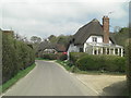
1
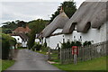
Thatched cottages on The Drive, Great Durnford
A private road leading to Great Durnford Manor.
Image: © David Martin
Taken: 29 Aug 2021
0.02 miles
2
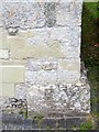
Bench Mark, St Andrew's Church
The bench mark is to be found on the south east angle of the church. For a view of the church Image and for information about the cut mark http://www.bench-marks.org.uk/bm34667
A bench mark is an Ordnance Survey arrowhead sign found on walls, bridges, churches and specially erected triangulation pillars where the altitude above sea-level has been accurately measured by surveyors. The arrowhead points to a horizontal line above it which marks the exact altitude.
With rivets and pivots there is no datum (horizontal line) cut, the pointed-to horizontal surface defining the datum height.
Image: © Maigheach-gheal
Taken: 6 Jun 2010
0.08 miles
3
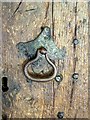
Detail, St Andrew's Church
The handle is to be found on the main door to the church. For a view of the church Image
Image: © Maigheach-gheal
Taken: 6 Jun 2010
0.08 miles
4
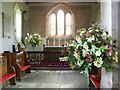
Chancel, St Andrew's Church
The nave and chancel were begun soon after the Norman Conquest.
Image: © Maigheach-gheal
Taken: 6 Jun 2010
0.08 miles
5
Grade II listed cottages
The 18th C. Hawthorne Cottage is nearest to us (although the conservatory is somewhat later). The cottage is Grade II listed with English Heritage Building ID: 321429.
Just beyond is the earlier 16th C. Woodrow Cottage. It has the same grade of listing with English Heritage Building ID: 321428.
Image: © Stuart Logan
Taken: 25 Apr 2013
0.08 miles
6
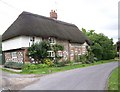
Thatched cottage, Great Durnford
One of the many thatched cottages in the village.
Image: © Maigheach-gheal
Taken: 3 Aug 2008
0.08 miles
7
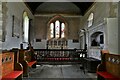
Great Durnford, St. Andrew's Church: The chancel
Image: © Michael Garlick
Taken: 3 Jun 2021
0.08 miles
8
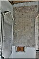
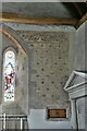
Great Durnford, St. Andrew's Church: Fragment of a wall painting
Image: © Michael Garlick
Taken: 3 Jun 2021
0.08 miles
9
Great Durnford, St. Andrew's Church: Fragment of a wall painting
Image: © Michael Garlick
Taken: 3 Jun 2021
0.08 miles
10
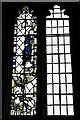
Great Durnford, St. Andrew's Church: Medieval glass fragments
Image: © Michael Garlick
Taken: 3 Jun 2021
0.08 miles