IMAGES TAKEN NEAR TO
High Post, SALISBURY, SP4 6AT
Introduction
This page details the photographs taken nearby to SP4 6AT by members of the Geograph project.
The Geograph project started in 2005 with the aim of publishing, organising and preserving representative images for every square kilometre of Great Britain, Ireland and the Isle of Man.

There are currently over 7.5m images from over14,400 individuals and you can help contribute to the project by visiting https://www.geograph.org.uk
Image Map
Images are licensed for reuse under creativecommons.org/licenses/by-sa/2.0
Notes
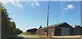
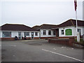
- Clicking on the map will re-center to the selected point.
- The higher the marker number, the further away the image location is from the centre of the postcode.
Image Listing (11 Images Found)
Images are licensed for reuse under creativecommons.org/licenses/by-sa/2.0
Image
Details
Distance
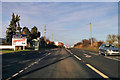
2
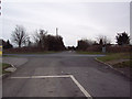
High Post
A view looking north along the A345 at the High Post crossroads, towards the filling station and the hotel. The Puma helicopter was purely co-incidental!
Image: © Phil Williams
Taken: 5 Apr 2006
0.06 miles
3
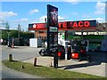
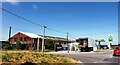
Service station and convenience store, A345, High Post
Now Texaco, not long ago it was Gulf Image I have to confess I've lost track of the buy-outs, buy-ins, mergers and takeovers that have taken place in the oil industry over the last few years.
Image: © Brian Robert Marshall
Taken: 12 Apr 2011
0.08 miles
4
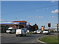
Traffic lights at High Post
Traffic lights taking vehicles safely onto the A345 at High Post.
Image: © Maigheach-gheal
Taken: 13 Feb 2007
0.09 miles
6
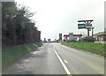
A345 approaches crossroads at High Post
The hotel is boarded up and the whole site gives the appearance of being un-cared for.
Image: © Stuart Logan
Taken: 25 Apr 2013
0.09 miles
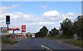
7
A345 towards Amesbury at High Post
Passing a business park with crossroads and fuel ahead.
Image: © Robin Webster
Taken: 16 Dec 2017
0.10 miles
8
Murco filling station on A345
At High Post crossroads.
Image: © Julian P Guffogg
Taken: 12 Aug 2013
0.10 miles
9
Clubhouse at High Post Golf Course
A modern structure just off the minor road.
Image: © Maigheach-gheal
Taken: 13 Feb 2007
0.15 miles
10
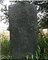
Old Milestone by the A345, High Post, Winterbourne parish
Carved stone post by the A345, in parish of Winterbourne (Salisbury District), High Post; 100m South of factory entrance, on shallow verge, on East side of road. Salisbury Roman stone, erected by the Marlborough & Salisbury turnpike trust in the 19th century.
Inscription reads:-
To
Salifbury
IV
Miles
To
Marlbro
XXIII
Carved benchmark recorded.
Grade II listed.
List Entry Number: 1130766 https://historicengland.org.uk/listing/the-list/list-entry/1130766
Milestone Society National ID: WI_MLSA23
Image: © M Faherty
Taken: 11 Aug 2007
0.16 miles