IMAGES TAKEN NEAR TO
Little Durnford, SALISBURY, SP4 6AJ
Introduction
This page details the photographs taken nearby to SP4 6AJ by members of the Geograph project.
The Geograph project started in 2005 with the aim of publishing, organising and preserving representative images for every square kilometre of Great Britain, Ireland and the Isle of Man.

There are currently over 7.5m images from over14,400 individuals and you can help contribute to the project by visiting https://www.geograph.org.uk
Image Map (Loading...)


Getting Data...Please wait
Leaflet Map data © OpenStreetMap
Images are licensed for reuse under creativecommons.org/licenses/by-sa/2.0
Notes
- Clicking on the map will re-center to the selected point.
- The higher the marker number, the further away the image location is from the centre of the postcode.
Image Listing (35 Images Found)
Images are licensed for reuse under creativecommons.org/licenses/by-sa/2.0
Image
Details
Distance
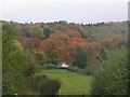
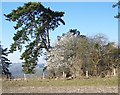
2
Bridleway near Little Durnford
The bridleway nears woodland on its way to Little Durnford.
Image: © Maigheach-gheal
Taken: 16 Feb 2008
0.14 miles
4
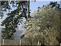
Blossom near Woodford
Early blossom.
Image: © Maigheach-gheal
Taken: 16 Feb 2008
0.15 miles
5
Woodland near Little Durnford
I don't know which particular tree is in blossom.
Image: © Maigheach-gheal
Taken: 16 Feb 2008
0.15 miles
6
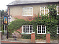
The Wheatsheaf, Lower Woodford
A traditional village hostelry.
Image: © Stuart Logan
Taken: 26 Jul 2011
0.17 miles
7
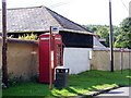
Telephone box, Lower Woodford
A K6 type telephone box in the centre of the village.
Image: © Maigheach-gheal
Taken: 3 Aug 2009
0.18 miles
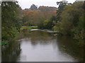
8
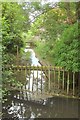
Mill stream, Lower Woodford
From a footbridge on the Monarch's Way.
Image: © Derek Harper
Taken: 17 Jul 2016
0.19 miles
9
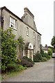
The Court House, Lower Woodford
The Monarch's Way runs past the façade of this listed house https://www.historicengland.org.uk/listing/the-list/list-entry/1284061 ; the image shows the "shaped gable over two central bays, disguising chimneys".
Image: © Derek Harper
Taken: 17 Jul 2016
0.20 miles
10
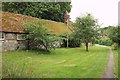
Monarch's Way at Lower Woodford #1
The Way follows footpath WFOR 4 past The Granary, which has attractively-patterned flint walls.
Image: © Derek Harper
Taken: 17 Jul 2016
0.20 miles