IMAGES TAKEN NEAR TO
Porton, SALISBURY, SP4 0NF
Introduction
This page details the photographs taken nearby to SP4 0NF by members of the Geograph project.
The Geograph project started in 2005 with the aim of publishing, organising and preserving representative images for every square kilometre of Great Britain, Ireland and the Isle of Man.

There are currently over 7.5m images from over14,400 individuals and you can help contribute to the project by visiting https://www.geograph.org.uk
Image Map
Images are licensed for reuse under creativecommons.org/licenses/by-sa/2.0
Notes
- Clicking on the map will re-center to the selected point.
- The higher the marker number, the further away the image location is from the centre of the postcode.
Image Listing (5 Images Found)
Images are licensed for reuse under creativecommons.org/licenses/by-sa/2.0
Image
Details
Distance
1
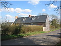
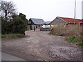
Field Farm
A view looking southeast towards the buildings of Field Farm.
Image: © Phil Williams
Taken: 5 Apr 2006
0.02 miles
4

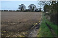
Rosebay willow-herb, Porton
Beside the Winterslow Road there is a double hedge where many wildflowers grow in profusion including Rosebay willow-herb.
Named after its long, narrow, willow like leaves, the willow-herb grows as an upright spike covered with pink flowers.
Rosebay willow-herb, or fireweed, was a rare native species which suddenly began to spread in about 1860, perhaps as a result of genetic change; it is now everywhere, except the far west of Ireland, and is abundant on waste land round towns, in cleared woodland and road side verges.
Image: © Maigheach-gheal
Taken: 21 Jun 2011
0.10 miles
5
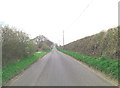
Winterslow Road northwest of Birdlymes Farm
Image: © Stuart Logan
Taken: 25 Apr 2013
0.21 miles