IMAGES TAKEN NEAR TO
Amesbury Road, SALISBURY, SP4 0HN
Introduction
This page details the photographs taken nearby to Amesbury Road, SP4 0HN by members of the Geograph project.
The Geograph project started in 2005 with the aim of publishing, organising and preserving representative images for every square kilometre of Great Britain, Ireland and the Isle of Man.

There are currently over 7.5m images from over14,400 individuals and you can help contribute to the project by visiting https://www.geograph.org.uk
Image Map
Images are licensed for reuse under creativecommons.org/licenses/by-sa/2.0
Notes
- Clicking on the map will re-center to the selected point.
- The higher the marker number, the further away the image location is from the centre of the postcode.
Image Listing (6 Images Found)
Images are licensed for reuse under creativecommons.org/licenses/by-sa/2.0
Image
Details
Distance
1
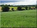
Farmland, Newton Tony
Above Cholderton Road and Red Cottage.
Image: © Andrew Smith
Taken: 26 Jun 2007
0.15 miles
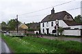
2
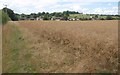
Newton Tony from the north
Houses along Beechfield seen from the footpath from Cholderton, running beside a rapeseed field.
Image: © Derek Harper
Taken: 2 Aug 2010
0.16 miles
3
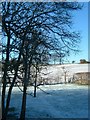
Winter view at the back of Beechfield looking west across the conservation area
Temperature of -4 degrees C
Image: © Derek Buckle
Taken: Unknown
0.19 miles
4
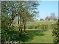
Spring view at the rear of Beechfield looking west across conservation area.
Image: © Derek Buckle
Taken: Unknown
0.21 miles
5
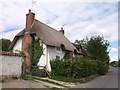
Cottage in Newton Tony
An C18 thatched cottage on Beechfield, with patterned brick on the stack http://www.britishlistedbuildings.co.uk/en-319993-11-newton-tony .
Image: © Derek Harper
Taken: 2 Aug 2010
0.22 miles
6
Newton Tony
The river running through the village was dry, even though the picture was taken in May.
Image: © Ron Strutt
Taken: 3 May 2004
0.24 miles