IMAGES TAKEN NEAR TO
St. Just Close, SALISBURY, SP4 0HB
Introduction
This page details the photographs taken nearby to St. Just Close, SP4 0HB by members of the Geograph project.
The Geograph project started in 2005 with the aim of publishing, organising and preserving representative images for every square kilometre of Great Britain, Ireland and the Isle of Man.

There are currently over 7.5m images from over14,400 individuals and you can help contribute to the project by visiting https://www.geograph.org.uk
Image Map
Images are licensed for reuse under creativecommons.org/licenses/by-sa/2.0
Notes
- Clicking on the map will re-center to the selected point.
- The higher the marker number, the further away the image location is from the centre of the postcode.
Image Listing (46 Images Found)
Images are licensed for reuse under creativecommons.org/licenses/by-sa/2.0
Image
Details
Distance
1
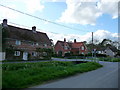
Newton Tony - Junction
Road junction in the centre of Newton Tony.
Image: © Chris Talbot
Taken: 25 Apr 2009
0.01 miles
2
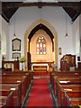
Newton Tony - St Andrews Church
There has been a church on this site since at least the 12th century, the current building is however much younger.
Image: © Chris Talbot
Taken: 25 Apr 2009
0.01 miles
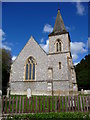
3
Newton Tony - St Andrews Church
The current St Andrews church was built on the site of a much older church and was opened in 1844.The church was designed in a 14th century style by Wyatt and Brandon.
Image: © Chris Talbot
Taken: 25 Apr 2009
0.01 miles
4
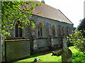
Newton Tony - St Andrews Church
This view of St Andrews shows part of the rear of the church. Trees and a fence prevented a fuller shot of this 14th century style church.
Image: © Chris Talbot
Taken: 25 Apr 2009
0.01 miles
5
Newton Tony - St Andrews Church
Looking from the nave of St Andrews towards the chancel.
Image: © Chris Talbot
Taken: 24 Apr 2009
0.01 miles
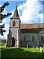
6
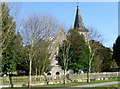
St Andrew's Church, Newton Tony
The flint and limestone church was built in 1844 by Wyatt and Brandon.
Image: © Maigheach-gheal
Taken: 26 Feb 2012
0.05 miles
7
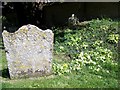
Primroses, St Andrew's Churchyard
The Primrose flowers in early spring, one of the earliest spring flowers in much of Europe. In appropriate conditions, it can cover the ground in open woods and shaded hedgerows.
In more populated areas it has sometimes suffered from over-collection and theft so that few natural displays of Primroses in abundance can now be found. To prevent excessive damage to the species, picking of Primroses or the removal of Primrose plants from the wild is illegal.
In the Middle Ages, a concoction was made from the foliage for treating gout and rheumatism, and an infusion of the roots was used for headaches.
Image: © Maigheach-gheal
Taken: 23 Apr 2010
0.05 miles
8
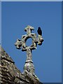
Jackdaw (Corvus monedula)
A jackdaw has found a perch high up on the roof of St Andrew's Church.
The jackdaw is a social and adaptable bird, nesting in colonies in suitable holes or crevices in rural and urban localities. It has a varied diet including insects and seeds - and it often scavenges. Its contact call is a high 'tchak'.
Image: © Maigheach-gheal
Taken: 23 Apr 2010
0.05 miles
9
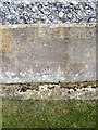
Bench Mark, St Andrew's Church
The bench mark is on the south-west wall of the church. For a view of the church Image and http://www.bench-marks.org.uk/bm34111
A bench mark is an Ordnance Survey arrowhead sign found on walls, bridges, churches and specially erected triangulation pillars where the altitude above sea-level has been accurately measured by surveyors. The arrowhead points to a horizontal line above it, or in this case below it, which marks the exact altitude.
With rivets and pivots there is no datum (horizontal line) cut, the pointed-to horizontal surface defining the datum height.
Image: © Maigheach-gheal
Taken: 23 Apr 2010
0.05 miles
10
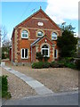
Newton Tony - Converted Chapel
This converted Wesleyan chapel was built in 1877.
Image: © Chris Talbot
Taken: 25 Apr 2009
0.05 miles