IMAGES TAKEN NEAR TO
Beech Hanger, SALISBURY, SP4 0EX
Introduction
This page details the photographs taken nearby to Beech Hanger, SP4 0EX by members of the Geograph project.
The Geograph project started in 2005 with the aim of publishing, organising and preserving representative images for every square kilometre of Great Britain, Ireland and the Isle of Man.

There are currently over 7.5m images from over14,400 individuals and you can help contribute to the project by visiting https://www.geograph.org.uk
Image Map
Images are licensed for reuse under creativecommons.org/licenses/by-sa/2.0
Notes
- Clicking on the map will re-center to the selected point.
- The higher the marker number, the further away the image location is from the centre of the postcode.
Image Listing (73 Images Found)
Images are licensed for reuse under creativecommons.org/licenses/by-sa/2.0
Image
Details
Distance
1
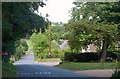
Grateley Road, Cholderton
The road drops down into the Bourne valley as it enters the village.
Image: © Derek Harper
Taken: 2 Aug 2010
0.07 miles
2
Cholderton: postbox № SP4 450, Edric?s Green
A small postbox, one of two in the village, which is emptied at 4pm on weekdays and at 7:30am on Saturdays.
Image: © Chris Downer
Taken: 14 Feb 2009
0.07 miles
3
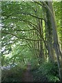
Line of beeches, Cholderton
These line the Grateley Road out of the village as far as the county boundary.
Image: © Derek Harper
Taken: 2 Aug 2010
0.09 miles
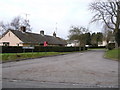
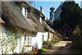
4
Church Field, Cholderton
Archaeological field walking survey taking place on Church Field, Cholderton Estate. Houses in Beech Hangar visible on the far side of the field.
Image: © Cynthia Poole
Taken: 13 Oct 2017
0.09 miles
5
St. Nicholas Church, Cholderton, Wiltshire
Image: © Andrew Mathewson
Taken: 5 Mar 2010
0.12 miles
6
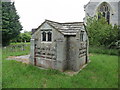
Cholderton - Crypt
This small crypt surrounded by an iron fence stands in the graveyard of St Nicholas Church.
Image: © Chris Talbot
Taken: 6 Jun 2009
0.12 miles
7
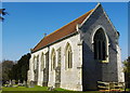
St. Nicholas' Church, Cholderton, Wiltshire
Image: © Andrew Mathewson
Taken: 5 Mar 2010
0.12 miles
8
Holly Tree Farmhouse, Cholderton
An C18 farmhouse on a corner of Grateley Road http://www.britishlistedbuildings.co.uk/en-319932-holly-tree-farmhouse-cholderton , facing the River Bourne and with a roofed wall.
Image: © Derek Harper
Taken: 2 Aug 2010
0.12 miles
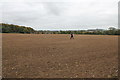
9
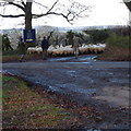
Herding sheep down Smugs Lane, Cholderton
At the crossroads of the Avenue and Smugs Lane (the Wiltshire/Hampshire county boundary)herding a flock of Hampshire Down sheep to Home Farm.
Image: © Cynthia Poole
Taken: 28 Dec 2013
0.13 miles
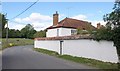
10
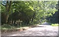
County boundary
Grateley Road crosses from Wiltshire into Hampshire at this road junction, and becomes Cholderton Road.
Image: © Derek Harper
Taken: 2 Aug 2010
0.14 miles