IMAGES TAKEN NEAR TO
Tidworth Road, SALISBURY, SP4 0BL
Introduction
This page details the photographs taken nearby to Tidworth Road, SP4 0BL by members of the Geograph project.
The Geograph project started in 2005 with the aim of publishing, organising and preserving representative images for every square kilometre of Great Britain, Ireland and the Isle of Man.

There are currently over 7.5m images from over14,400 individuals and you can help contribute to the project by visiting https://www.geograph.org.uk
Image Map
Images are licensed for reuse under creativecommons.org/licenses/by-sa/2.0
Notes
- Clicking on the map will re-center to the selected point.
- The higher the marker number, the further away the image location is from the centre of the postcode.
Image Listing (26 Images Found)
Images are licensed for reuse under creativecommons.org/licenses/by-sa/2.0
Image
Details
Distance
1
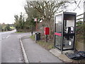
Boscombe: postbox № SP4 270 and phone
These facilities are in a bus layby on the A338, opposite Image The postbox was probably moved over this side having been outside the post office when it was operational. The box is emptied at 4:30pm on weekdays and at 9:30 on Saturday mornings.
Image: © Chris Downer
Taken: 14 Feb 2009
0.07 miles
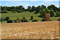
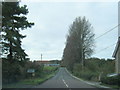
3
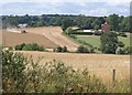
Harvesting at Allington
A view from the gate on the left of Image The harvester is working on the other side of the Bourne. On the right is The Old Rectory which straddles a northing gridline.
Image: © Derek Harper
Taken: 2 Aug 2010
0.07 miles
5
Boscombe: the Old Post Office
I recall the post office here; it must have closed down around 2000. I'm fairly sure it was demolished and this built in its place.
Image: © Chris Downer
Taken: 14 Feb 2009
0.09 miles
6
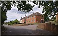
Bourne View, Allington
Together with a farm and the old rectory, Bourne View forms a detached part of Allington between the village and Boscombe. Seen here from its junction with the A338.
Image: © Derek Harper
Taken: 2 Aug 2010
0.09 miles
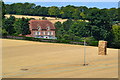
7
Haystacks in field below Cloudlands Farm
Image: © David Martin
Taken: 20 Jul 2020
0.11 miles
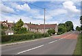
8
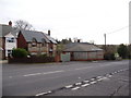
Cottages by the A338
School Cottages are next to the former post office. The main road crosses Boscombe Bridge over the (dry) River Bourne in the foreground; Image was taken from here.
Image: © Derek Harper
Taken: 2 Aug 2010
0.11 miles
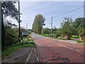
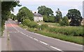
10
Buildings on the A338, Allington
These buildings demonstrate the predominance of brick and flint as building materials in this area. The red road surface is visible in Image, showing where that photo was taken, looking in the other direction.
Image: © Derek Harper
Taken: 2 Aug 2010
0.15 miles