IMAGES TAKEN NEAR TO
The Old Farm Yard, SALISBURY, SP3 6NZ
Introduction
This page details the photographs taken nearby to The Old Farm Yard, SP3 6NZ by members of the Geograph project.
The Geograph project started in 2005 with the aim of publishing, organising and preserving representative images for every square kilometre of Great Britain, Ireland and the Isle of Man.

There are currently over 7.5m images from over14,400 individuals and you can help contribute to the project by visiting https://www.geograph.org.uk
Image Map
Images are licensed for reuse under creativecommons.org/licenses/by-sa/2.0
Notes
- Clicking on the map will re-center to the selected point.
- The higher the marker number, the further away the image location is from the centre of the postcode.
Image Listing (54 Images Found)
Images are licensed for reuse under creativecommons.org/licenses/by-sa/2.0
Image
Details
Distance
1
Bench Mark, Tisbury
The mark is to be found on the wall of 105 Court Street. http://www.bench-marks.org.uk/bm33398
Image: © Maigheach-gheal
Taken: 10 Mar 2010
0.05 miles
3
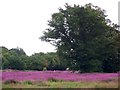
Rosebay Willow-herb, Tisbury
Named after its long, narrow, willow like leaves, the willow-herb grows as an upright spike covered with pink flowers.
Rosebay willow-herb, or fireweed, was a rare native species which suddenly began to spread in about 1860, perhaps as a result of genetic change; it is now everywhere, except the far west of Ireland, and is abundant on waste land round towns, in cleared woodland and road side verges.
Here it is growing in a rough grazing field beside the railway embankment. This field often floods.
Image: © Maigheach-gheal
Taken: 11 Jul 2009
0.10 miles
4
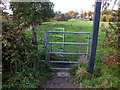
Kissing gate
The gate allows access to the footpath that leads from Court Street to The Avenue, the trees on the left line the bank of the River Nadder.
Image: © Jonathan Kington
Taken: 29 Oct 2011
0.10 miles
5
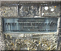
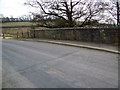
Plaque on the bridge
Plaque on the west buttress of Court Street Bridge (R11/10) commemorating its rebuild in 1949, H S Canderton OBE was the then County Surveyor. See Image for a wider view.
Image: © Jonathan Kington
Taken: 29 Oct 2011
0.11 miles
6
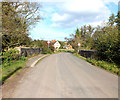
Over the bridge
The bridge takes Court Street Bridge over the River Nadder. There is a bench mark on the left-hand buttress, see Image by Trish Steel. Also on the left-hand buttress is a plaque commemorating the rebuilding of the bridge in 1949, see Image
Image: © Jonathan Kington
Taken: 29 Oct 2011
0.11 miles
7
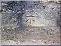
Bench Mark, Tisbury
The bench mark is to be found on the face of Court Street Bridge. Image and http://www.bench-marks.org.uk/bm33547
A bench mark is an Ordnance Survey arrowhead sign found on walls, bridges, churches and specially erected concrete posts where the altitude above sea-level has been accurately measured by surveyors. The arrowhead points to a horizontal line above it which marks the exact altitude.
Image: © Maigheach-gheal
Taken: 17 Mar 2010
0.11 miles
8
Court Street Bridge, Tisbury
There is a cut bench mark on the bridge over the River Nadder. See Image
Image: © Maigheach-gheal
Taken: 17 Mar 2010
0.11 miles
9
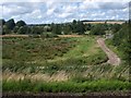
Nadder valley at Tisbury
A water meadow beside a track running to meet the road arriving at the east end of the village from Ansty. The river runs across the image beside the mature trees in the centre. On the far side the Fonthill stream valley joins the Nadder. Seen from the railway track glimpsed in the foreground.
Image: © Derek Harper
Taken: 30 Jul 2009
0.11 miles