IMAGES TAKEN NEAR TO
Tisbury Row, SALISBURY, SP3 6LT
Introduction
This page details the photographs taken nearby to Tisbury Row, SP3 6LT by members of the Geograph project.
The Geograph project started in 2005 with the aim of publishing, organising and preserving representative images for every square kilometre of Great Britain, Ireland and the Isle of Man.

There are currently over 7.5m images from over14,400 individuals and you can help contribute to the project by visiting https://www.geograph.org.uk
Image Map (Loading...)


Getting Data...Please wait
Leaflet Map data © OpenStreetMap
Images are licensed for reuse under creativecommons.org/licenses/by-sa/2.0
Notes
- Clicking on the map will re-center to the selected point.
- The higher the marker number, the further away the image location is from the centre of the postcode.
Image Listing (47 Images Found)
Images are licensed for reuse under creativecommons.org/licenses/by-sa/2.0
Image
Details
Distance
1
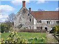
The Old Mill, Tisbury
Tisbury Mill was functioning from about 1086 until 1919 and for a further twenty years electricity was generated here.
Image: © Maigheach-gheal
Taken: 27 Mar 2008
0.02 miles
2
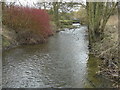
The automatic sluice at Tisbury mill
Looking upstream to the mill. An Environment Agency notice on the sluice structure describes it thus; "Tisbury Mill lifting gates".
Image: © David Redwood
Taken: 22 Feb 2012
0.03 miles
3
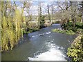
River Nadder, Tisbury Mill
Taken from the bridge over the weir.
Image: © Maigheach-gheal
Taken: 27 Mar 2008
0.04 miles
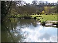
5
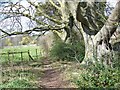
River Nadder, Tisbury
The River Nadder (downstream) near Tisbury Mill.
Image: © Maigheach-gheal
Taken: 27 Mar 2008
0.06 miles
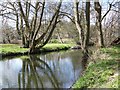
6
River Nadder, Tisbury Mill
Looking upstream. A good place to see Kingfishers.
Image: © Maigheach-gheal
Taken: 27 Mar 2008
0.07 miles
7
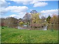
Pond at Tisbury Mill
Pond next to the mill.
Image: © Maigheach-gheal
Taken: 27 Mar 2008
0.07 miles
8
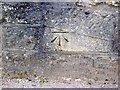
Bench Mark, Tisbury
The bench mark is to be found on the face of Court Street Bridge. Image and http://www.bench-marks.org.uk/bm33547
A bench mark is an Ordnance Survey arrowhead sign found on walls, bridges, churches and specially erected concrete posts where the altitude above sea-level has been accurately measured by surveyors. The arrowhead points to a horizontal line above it which marks the exact altitude.
Image: © Maigheach-gheal
Taken: 17 Mar 2010
0.11 miles
9
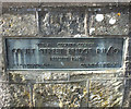
Plaque on the bridge
Plaque on the west buttress of Court Street Bridge (R11/10) commemorating its rebuild in 1949, H S Canderton OBE was the then County Surveyor. See Image for a wider view.
Image: © Jonathan Kington
Taken: 29 Oct 2011
0.11 miles
10
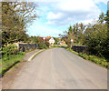
Over the bridge
The bridge takes Court Street Bridge over the River Nadder. There is a bench mark on the left-hand buttress, see Image by Trish Steel. Also on the left-hand buttress is a plaque commemorating the rebuilding of the bridge in 1949, see Image
Image: © Jonathan Kington
Taken: 29 Oct 2011
0.11 miles