IMAGES TAKEN NEAR TO
High Street, SALISBURY, SP3 6HH
Introduction
This page details the photographs taken nearby to High Street, SP3 6HH by members of the Geograph project.
The Geograph project started in 2005 with the aim of publishing, organising and preserving representative images for every square kilometre of Great Britain, Ireland and the Isle of Man.

There are currently over 7.5m images from over14,400 individuals and you can help contribute to the project by visiting https://www.geograph.org.uk
Image Map (Loading...)


Getting Data...Please wait
Leaflet Map data © OpenStreetMap
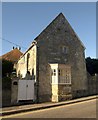
Images are licensed for reuse under creativecommons.org/licenses/by-sa/2.0
Notes
- Clicking on the map will re-center to the selected point.
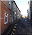
- The higher the marker number, the further away the image location is from the centre of the postcode.
Image Listing (129 Images Found)
Images are licensed for reuse under creativecommons.org/licenses/by-sa/2.0
Image
Details
Distance
1
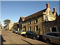
The Elms, Tisbury
An C18 house on the main village street, with prominent rusticated quoins http://www.britishlistedbuildings.co.uk/en-321022-the-elms-tisbury . Just up the road is Image
Image: © Derek Harper
Taken: 9 Jan 2011
0.00 miles
2
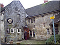
The Boot Inn, Tisbury
Built around 1600 with additions to the front from both the 1700 and the 19th century. It is timber framed with rubble stone infill and dressed limestone additions. It is Grade II listed.
Image: © Maigheach-gheal
Taken: 11 Jan 2007
0.01 miles
3
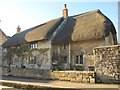
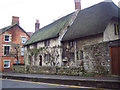
The Old House, Tisbury
This thatched house is C17 (left) with an C18 addition to the right http://www.britishlistedbuildings.co.uk/en-321031-the-old-house-tisbury .
Image: © Derek Harper
Taken: 9 Jan 2011
0.01 miles
4
The Old House, Tisbury
The thatched roof High Street house on the corner of Weaveland Road dates from the mid 17th century.
Image: © Jaggery
Taken: 13 Dec 2014
0.01 miles
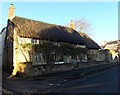
5
The Old House, Tisbury
A mid 17th century house of dressed limestone. It was altered in the early 18th century. The house is Grade II listed.
Image: © Maigheach-gheal
Taken: 11 Jan 2007
0.01 miles
6
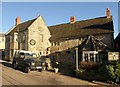
The Boot Inn, Tisbury
The inn dates originally from about 1600 http://www.britishlistedbuildings.co.uk/en-321020-the-boot-inn-tisbury . On the left, to the right of the bay, is a tablet bearing the name of the inn. Below, across the whole wing, are the words "BENETT AND INDEPENDENCE", an electioneering slogan.
Image: © Derek Harper
Taken: 9 Jan 2011
0.02 miles
7
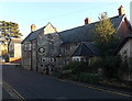
The Boot Inn, Tisbury
Viewed across High Street.
Image: © Jaggery
Taken: 13 Dec 2014
0.02 miles
8
House in Tisbury
Little Haddon House is on the upper part of the High Street. To the left is Image
Image: © Derek Harper
Taken: 9 Jan 2011
0.02 miles
9
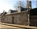
Old School House, Tisbury
Lying at right angles to the High Street, with a canted bay jutting onto the pavement, the building is C17 http://www.britishlistedbuildings.co.uk/en-321029-old-school-house-tisbury .
Image: © Derek Harper
Taken: 9 Jan 2011
0.03 miles
10
Weaveland Road, Tisbury
Weaveland Road ascends from High Street.
Image: © Jaggery
Taken: 13 Dec 2014
0.03 miles