IMAGES TAKEN NEAR TO
Snow Hill, SALISBURY, SP3 5HN
Introduction
This page details the photographs taken nearby to Snow Hill, SP3 5HN by members of the Geograph project.
The Geograph project started in 2005 with the aim of publishing, organising and preserving representative images for every square kilometre of Great Britain, Ireland and the Isle of Man.

There are currently over 7.5m images from over14,400 individuals and you can help contribute to the project by visiting https://www.geograph.org.uk
Image Map
Images are licensed for reuse under creativecommons.org/licenses/by-sa/2.0
Notes
- Clicking on the map will re-center to the selected point.
- The higher the marker number, the further away the image location is from the centre of the postcode.
Image Listing (135 Images Found)
Images are licensed for reuse under creativecommons.org/licenses/by-sa/2.0
Image
Details
Distance
2
![Dinton houses [6]](https://s3.geograph.org.uk/geophotos/07/34/67/7346711_3b8b8394_120x120.jpg)
Dinton houses [6]
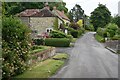
Wheatsheaf Cottage, Snow Hill, has a central range with flanking wings. The central range was rebuilt in the 18th century incorporating the remains of a small late medieval hall house, and the wing to the left was added at the same date. The wing on the right is 20th century. Constructed of rubble stone with some timber framing with brick nogging, all under a thatch roof. Some early internal features remain. Known as the Wyndham Arms during the 19th century and later as The Wheatsheaf Inn. There is another view of the cottages at: Image Listed, grade II, with details at: https://historicengland.org.uk/listing/the-list/list-entry/1283492
Dinton is a village in the Nadder valley, in Wiltshire, about 8¼ miles west of Salisbury and some 10½ miles northeast of Shaftesbury. Evidence of ancient settlement in the area is plentiful, including Grim's Ditch, Hanging Langford Camp, an Iron Age settlement, and the hill fort of Wick Ball Camp. Dinton is now a commuter village with most working residents travelling to Salisbury.
Image: © Michael Dibb
Taken: 30 Aug 2022
0.04 miles
3
![Dinton houses [7]](https://s0.geograph.org.uk/geophotos/07/34/67/7346712_f2a219af_120x120.jpg)
Dinton houses [7]
Wheatsheaf Cottage, Snow Hill, has a central range with flanking wings. The central range was rebuilt in the 18th century incorporating the remains of a small late medieval hall house, and the wing to the left was added at the same date. The wing on the right is 20th century. Constructed of rubble stone with some timber framing with brick nogging, all under a thatch roof. Some early internal features remain. Known as the Wyndham Arms during the 19th century and later as The Wheatsheaf Inn. There is another view of the cottage at: Image Listed, grade II, with details at: https://historicengland.org.uk/listing/the-list/list-entry/1283492
Dinton is a village in the Nadder valley, in Wiltshire, about 8¼ miles west of Salisbury and some 10½ miles northeast of Shaftesbury. Evidence of ancient settlement in the area is plentiful, including Grim's Ditch, Hanging Langford Camp, an Iron Age settlement, and the hill fort of Wick Ball Camp. Dinton is now a commuter village with most working residents travelling to Salisbury.
Image: © Michael Dibb
Taken: 30 Aug 2022
0.04 miles
4
![Dinton houses [8]](https://s3.geograph.org.uk/geophotos/07/34/67/7346719_057cf006_120x120.jpg)
Dinton houses [8]
Jesses, Snow Hill, appears to date from the early 17th century. However, evidence suggests that it originated as a timber framed cruck house of circa 1500 or earlier. It was rebuilt in rubble stone under a thatch roof in the late 16th or early 17th century. The house was greatly remodelled in 1937 when the left gable and the rear wing to the right were added in 17th century style. Jesses were a prominent family farming in Dinton from at least the 16th century. Some early internal features and fittings remain. There is another view of the house at Image Listed, grade II, with details at: https://historicengland.org.uk/listing/the-list/list-entry/1283485
Dinton is a village in the Nadder valley, in Wiltshire, about 8¼ miles west of Salisbury and some 10½ miles northeast of Shaftesbury. Evidence of ancient settlement in the area is plentiful, including Grim's Ditch, Hanging Langford Camp, an Iron Age settlement, and the hill fort of Wick Ball Camp. Dinton is now a commuter village with most working residents travelling to Salisbury.
Image: © Michael Dibb
Taken: 30 Aug 2022
0.06 miles
5
![Dinton houses [9]](https://s1.geograph.org.uk/geophotos/07/34/67/7346721_70ad2eb1_120x120.jpg)
Dinton houses [9]
Jesses, Snow Hill, appears to date from the early 17th century. However, evidence suggests that it originated as a timber framed cruck house of circa 1500 or earlier. It was rebuilt in rubble stone under a thatch roof in the late 16th or early 17th century. The house was greatly remodelled in 1937 when the left gable and the rear wing to the right (seen here) were added in 17th century style. Jesses were a prominent family farming in Dinton from at least the 16th century. Some early internal features and fittings remain. There is another view of the house at Image Listed, grade II, with details at: https://historicengland.org.uk/listing/the-list/list-entry/1283485
Dinton is a village in the Nadder valley, in Wiltshire, about 8¼ miles west of Salisbury and some 10½ miles northeast of Shaftesbury. Evidence of ancient settlement in the area is plentiful, including Grim's Ditch, Hanging Langford Camp, an Iron Age settlement, and the hill fort of Wick Ball Camp. Dinton is now a commuter village with most working residents travelling to Salisbury.
Image: © Michael Dibb
Taken: 30 Aug 2022
0.06 miles
6
![Dinton buildings [2]](https://s3.geograph.org.uk/geophotos/07/34/67/7346723_6937add8_120x120.jpg)
Dinton buildings [2]
The 4-bay barn, seen here, and converted to a dwelling, and the 5-bay sheltershed Image were outbuildings to Jesses Image Built in the 18th century, timber framed and clad with weatherboard under a thatch roof. Listed, grade II, with details at: https://historicengland.org.uk/listing/the-list/list-entry/1318762
Dinton is a village in the Nadder valley, in Wiltshire, about 8¼ miles west of Salisbury and some 10½ miles northeast of Shaftesbury. Evidence of ancient settlement in the area is plentiful, including Grim's Ditch, Hanging Langford Camp, an Iron Age settlement, and the hill fort of Wick Ball Camp. Dinton is now a commuter village with most working residents travelling to Salisbury.
Image: © Michael Dibb
Taken: 30 Aug 2022
0.09 miles
7
![Dinton buildings [3]](https://s1.geograph.org.uk/geophotos/07/34/67/7346725_54f401c8_120x120.jpg)
Dinton buildings [3]
The 5-bay sheltershed, seen here, and the 4-bay barn, converted to a dwelling Image were outbuildings to Jesses Image Built in the 18th century, timber framed and clad with weatherboard under a thatch roof. Listed, grade II, with details at: https://historicengland.org.uk/listing/the-list/list-entry/1318762
Dinton is a village in the Nadder valley, in Wiltshire, about 8¼ miles west of Salisbury and some 10½ miles northeast of Shaftesbury. Evidence of ancient settlement in the area is plentiful, including Grim's Ditch, Hanging Langford Camp, an Iron Age settlement, and the hill fort of Wick Ball Camp. Dinton is now a commuter village with most working residents travelling to Salisbury.
Image: © Michael Dibb
Taken: 30 Aug 2022
0.09 miles
8
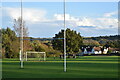
Goalposts on the green
On the recreation ground at Dinton.
Image: © David Martin
Taken: 1 Nov 2021
0.10 miles
9

Jubilee fete on the green at Dinton
With a jazz band playing in the blue-roofed gazebo on the left.
Image: © David Martin
Taken: 5 Jun 2022
0.11 miles
10
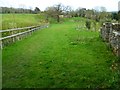
The Orange Way in Wiltshire (100)
The walk is through this field.
Image: © Shazz
Taken: 21 Apr 2013
0.11 miles