Dinton houses [7]
Introduction
The photograph on this page of Dinton houses [7] by Michael Dibb as part of the Geograph project.
The Geograph project started in 2005 with the aim of publishing, organising and preserving representative images for every square kilometre of Great Britain, Ireland and the Isle of Man.

There are currently over 7.5m images from over 14,400 individuals and you can help contribute to the project by visiting https://www.geograph.org.uk
Dinton houses [7]
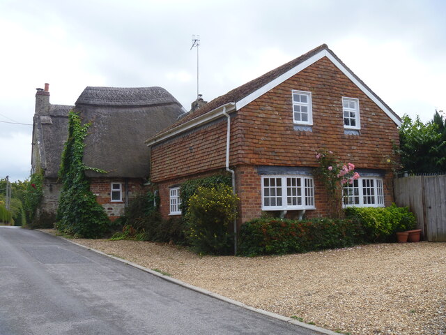
Image: © Michael Dibb Taken: 30 Aug 2022
Wheatsheaf Cottage, Snow Hill, has a central range with flanking wings. The central range was rebuilt in the 18th century incorporating the remains of a small late medieval hall house, and the wing to the left was added at the same date. The wing on the right is 20th century. Constructed of rubble stone with some timber framing with brick nogging, all under a thatch roof. Some early internal features remain. Known as the Wyndham Arms during the 19th century and later as The Wheatsheaf Inn. There is another view of the cottage at: Image Listed, grade II, with details at: https://historicengland.org.uk/listing/the-list/list-entry/1283492 Dinton is a village in the Nadder valley, in Wiltshire, about 8¼ miles west of Salisbury and some 10½ miles northeast of Shaftesbury. Evidence of ancient settlement in the area is plentiful, including Grim's Ditch, Hanging Langford Camp, an Iron Age settlement, and the hill fort of Wick Ball Camp. Dinton is now a commuter village with most working residents travelling to Salisbury.
Images are licensed for reuse under creativecommons.org/licenses/by-sa/2.0
Image Location
Latitude
51.083645
Longitude
-1.983146