IMAGES TAKEN NEAR TO
Hindon Road, SALISBURY, SP3 5EG
Introduction
This page details the photographs taken nearby to Hindon Road, SP3 5EG by members of the Geograph project.
The Geograph project started in 2005 with the aim of publishing, organising and preserving representative images for every square kilometre of Great Britain, Ireland and the Isle of Man.

There are currently over 7.5m images from over14,400 individuals and you can help contribute to the project by visiting https://www.geograph.org.uk
Image Map
Images are licensed for reuse under creativecommons.org/licenses/by-sa/2.0
Notes
- Clicking on the map will re-center to the selected point.
- The higher the marker number, the further away the image location is from the centre of the postcode.
Image Listing (28 Images Found)
Images are licensed for reuse under creativecommons.org/licenses/by-sa/2.0
Image
Details
Distance
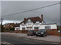
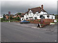
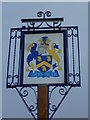
2
The Wyndham, Dinton
Platinum jubilee bunting in evidence.
Image: © David Martin
Taken: 5 Jun 2022
0.04 miles
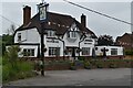
3
The Wyndham Arms
It used to be the Swordsman, and before that, the East End.
Image: © William Avery
Taken: 26 Oct 2006
0.05 miles
4
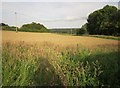
Field at Dinton
At last, after a nightmarish twenty minutes, I have found footpath DINT 13; it actually runs to the left of the camera up the side of the field. The path has been truncated by buildings; it starts from the B3069 and then gives up, re-emerging at this point from an alley beside Spracklands. Trouble is, the OS map shows it as continuous, and also shows the new buildings, so one would assume, as I did, that the two co-exist. No they don't. I went backwards and forwards about five times. What with problems with several footpaths at Fovant, and the tiring nature of such issues after many miles on the hoof, I've lost about an hour.
For the record, another path, DINT 5, runs blithely from west to east here, crossing this field.
Image: © Derek Harper
Taken: 27 Jun 2015
0.06 miles
6
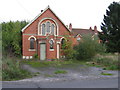
Primitive Methodist Chapel
Dated 1895
Image: © William Avery
Taken: 26 Oct 2006
0.08 miles
7
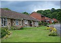
Spracklands, Dinton
An area of social housing.
Image: © Maigheach-gheal
Taken: 15 Jun 2008
0.11 miles
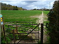
8
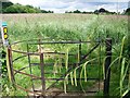
Kissing gate, Dinton
The gate takes the walker into a field of wheat, then on towards Baverstock.
Image: © Maigheach-gheal
Taken: 15 Jun 2008
0.12 miles
9
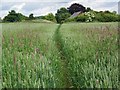
Footpath, Dinton
Although the field is planted with wheat there is a great deal of different grasses growing amongst it.
Image: © Maigheach-gheal
Taken: 15 Jun 2008
0.12 miles
10
The Orange Way in Wiltshire (104)
This is the path to East Farm.
Image: © Shazz
Taken: 22 Apr 2013
0.13 miles