IMAGES TAKEN NEAR TO
Frickers Paddock, SALISBURY, SP3 5BU
Introduction
This page details the photographs taken nearby to Frickers Paddock, SP3 5BU by members of the Geograph project.
The Geograph project started in 2005 with the aim of publishing, organising and preserving representative images for every square kilometre of Great Britain, Ireland and the Isle of Man.

There are currently over 7.5m images from over14,400 individuals and you can help contribute to the project by visiting https://www.geograph.org.uk
Image Map
Images are licensed for reuse under creativecommons.org/licenses/by-sa/2.0
Notes
- Clicking on the map will re-center to the selected point.
- The higher the marker number, the further away the image location is from the centre of the postcode.
Image Listing (47 Images Found)
Images are licensed for reuse under creativecommons.org/licenses/by-sa/2.0
Image
Details
Distance
1
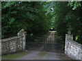
Gates, The Old Rectory, Chilmark
This is the entrance on the Salisbury Road to the Old Rectory in Chilmark, and it does not appear to be used very often. There is another entrance to the south in The Street, the main street in the village. The grounds of the rectory used to be known as Chilmark Park, and the Church fete has been held there for a long time.
When the house was up for sale in 2004 its 'edge of village' location was a selling point, http://www.telegraph.co.uk/property/main.jhtml?xml=/property/2004/05/26/pedge26.xml. The article has a picture of the Old Rectory. The house is a listed building, http://www.imagesofengland.org.uk/Details/Default.aspx?id=320332&mode=quick
Image: © Andy Gryce
Taken: 29 Jun 2007
0.09 miles
2
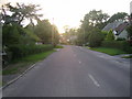
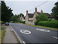
Salisbury Road, Chilmark
Salisbury Road, the main road through Chilmark, is the B3809 that runs east-west from the A30 at Barford St Martin to the A303 trunk road near West Knoyle. This was once the earliest road west from Salisbury when as a turnpike it went onto Shaftesbury. The road however was allowed to expire in 1788 when a new turnpike, now the route of the present A30, was constructed.
The Black Dog, the village's public house, can be seen in the distance, in Image, as the road curves to the left.
Image: © Andy Gryce
Taken: 29 Jun 2007
0.09 miles
3
Footpath, Barberry, Chilmark
This short village footpath runs from Burberry, the street that leads up to the church of St Margaret of Antioch, see Image, to Salisbury Road, the main road through Chilmark.
Image: © Andy Gryce
Taken: 29 Jun 2007
0.10 miles
4
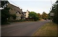
Salisbury Road Chilmark at sunset
Looking towards Dinton and the road to Salisbury at Chilmark.
Image: © roger geach
Taken: 30 Jun 2010
0.10 miles
5
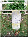
Milestone, Chilmark
Sarum (Salisbury) 12 miles and Hindon 4 miles.
Image: © Maigheach-gheal
Taken: 3 Nov 2009
0.12 miles
6
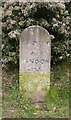
Old Milestone by the B3089, Salisbury Road, Chilmark
Carved stone post by the B3089, in parish of CHILMARK (SALISBURY District), Salisbury Road; 200m East of Black Dog PH, by Parsons Paddock, by the road, on Northeast side of road. Hindon stone, erected by the Fisherton, Wilton, Heytesbury, Willoughby Hedge & Redhone turnpike trust in the 19th century.
Inscription reads:-
SARUM
XII
HINDON
IV
Grade II listed.
List Entry Number: 1130699 https://historicengland.org.uk/listing/the-list/list-entry/1130699
Milestone Society National ID: WI_SAMR12.
Image: © M Faherty
Taken: 17 Feb 2007
0.12 miles
7
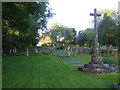
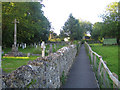
Graveyard, St Margaret of Antioch Church, Chilmark
This graveyard is at the east end of the church which is off camera to the left, see Image Although there seems to be plenty of space here, there is very little surrounding the other sides of the church, which is mainly in Image
Image: © Andy Gryce
Taken: 29 Jun 2007
0.12 miles
8
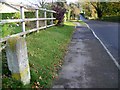
Milestone, Chilmark
Milestone beside the B3089 in the village of Chilmark. For a closer image see Image
Image: © Maigheach-gheal
Taken: 3 Nov 2009
0.12 miles
10
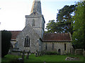
St Margaret of Antioch Church, Chilmark
Much of the parish church of Chilmark dates from the late 13th century when additions were made to an existing small church using stone from the Chilmark Quarries. The porch was added in the 14th century, the spire in the 18th century, and the north aisle and vestry in Victorian times. The church is a listed building, http://www.imagesofengland.org.uk/Details/Default.aspx?id=320298&mode=quick.
The ST97 easting grid line passes just to the right of the spire, so the chancel is in this grid square whilst the rest of the church lies in the adjacent grid square Image
St Margaret was a maiden Christian martyr in Antioch, Syria in the 3rd or 4th century, who was widely venerated in the Middle Ages. When she refused to marry the local Roman prefect, she was beheaded. Her proclamation as a patron saint of expectant mothers was based on the story that during her trials she was swallowed by Satan in the form of a dragon and later disgorged unharmed.
Image: © Andy Gryce
Taken: 29 Jun 2007
0.14 miles