IMAGES TAKEN NEAR TO
Winterbourne Stoke, SALISBURY, SP3 4TD
Introduction
This page details the photographs taken nearby to SP3 4TD by members of the Geograph project.
The Geograph project started in 2005 with the aim of publishing, organising and preserving representative images for every square kilometre of Great Britain, Ireland and the Isle of Man.

There are currently over 7.5m images from over14,400 individuals and you can help contribute to the project by visiting https://www.geograph.org.uk
Image Map (5 Images)


Getting Data...Please wait
Leaflet Map data © OpenStreetMap
Images are licensed for reuse under creativecommons.org/licenses/by-sa/2.0
Notes
- Clicking on the map will re-center to the selected point.
- The higher the marker number, the further away the image location is from the centre of the postcode.
Image Listing (5 Images Found)
Images are licensed for reuse under creativecommons.org/licenses/by-sa/2.0
Image
Details
Distance
1
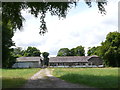
Hill Farm
These farm buildings now appear to be very little used although the farm has been here for a long time with some of the buildings dating back well before the Victorian era
Image: © Nigel Mykura
Taken: 27 Jul 2014
0.13 miles
2
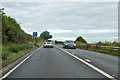
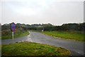
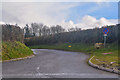
A303 heading west
The left turn goes to Hill Farm.
Image: © Robin Webster
Taken: 7 Sep 2019
0.23 miles
4
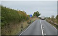
Wiltshire : Small Road
A road heading off the A303.
Image: © Lewis Clarke
Taken: 29 Mar 2018
0.23 miles