IMAGES TAKEN NEAR TO
Riverside Terrace, SALISBURY, SP3 4LF
Introduction
This page details the photographs taken nearby to Riverside Terrace, SP3 4LF by members of the Geograph project.
The Geograph project started in 2005 with the aim of publishing, organising and preserving representative images for every square kilometre of Great Britain, Ireland and the Isle of Man.

There are currently over 7.5m images from over14,400 individuals and you can help contribute to the project by visiting https://www.geograph.org.uk
Image Map
Images are licensed for reuse under creativecommons.org/licenses/by-sa/2.0
Notes
- Clicking on the map will re-center to the selected point.
- The higher the marker number, the further away the image location is from the centre of the postcode.
Image Listing (80 Images Found)
Images are licensed for reuse under creativecommons.org/licenses/by-sa/2.0
Image
Details
Distance
2
![Stapleford features [9]](https://s2.geograph.org.uk/geophotos/07/34/99/7349970_827a58eb_120x120.jpg)
Stapleford features [9]
The River Till, looking downstream from Bury Bridge, which carries Over Street.
Stapleford is a village on the River Till, just above its confluence with the River Wylye, in Wiltshire. The village is about 6¼ miles northwest of Salisbury and about 13 miles southeast of Warminster. Stapleford is astride the B3083 road, which joins the A36 at the southern end of the village. At the northern end of the village are the earthwork remains of Stapleford Castle, a medieval ringwork and bailey castle.
Image: © Michael Dibb
Taken: 30 Aug 2022
0.05 miles
4
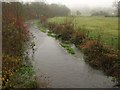
River Till at Stapleford
Looking downstream from Bury Bridge. Here it is about a kilometre from its junction with the Wylye.
Image: © Derek Harper
Taken: 11 Dec 2009
0.05 miles
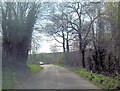
5
Seat overlooking the stream north of Bury Bridge
Image: © David Martin
Taken: 19 Mar 2022
0.07 miles
6
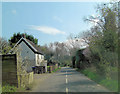
![Stapleford houses [17]](https://s3.geograph.org.uk/geophotos/07/34/99/7349971_ab401982_120x120.jpg)
Stapleford houses [17]
Bankside, Berwick Road, is a detached 18th century cottage. Constructed of cob under a hipped thatch roof. Listed, grade II, with details at: https://historicengland.org.uk/listing/the-list/list-entry/1146221
Stapleford is a village on the River Till, just above its confluence with the River Wylye, in Wiltshire. The village is about 6¼ miles northwest of Salisbury and about 13 miles southeast of Warminster. Stapleford is astride the B3083 road, which joins the A36 at the southern end of the village. At the northern end of the village are the earthwork remains of Stapleford Castle, a medieval ringwork and bailey castle.
Image: © Michael Dibb
Taken: 30 Aug 2022
0.08 miles
10
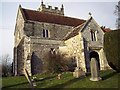
The Church of St Mary, Stapleford
The church is largely of flint, mixed with freestone and has a fifteenth century porch.
Image: © Maigheach-gheal
Taken: 8 Feb 2007
0.13 miles