IMAGES TAKEN NEAR TO
Chalk Hill, SALISBURY, SP3 4EU
Introduction
This page details the photographs taken nearby to Chalk Hill, SP3 4EU by members of the Geograph project.
The Geograph project started in 2005 with the aim of publishing, organising and preserving representative images for every square kilometre of Great Britain, Ireland and the Isle of Man.

There are currently over 7.5m images from over14,400 individuals and you can help contribute to the project by visiting https://www.geograph.org.uk
Image Map
Images are licensed for reuse under creativecommons.org/licenses/by-sa/2.0
Notes
- Clicking on the map will re-center to the selected point.
- The higher the marker number, the further away the image location is from the centre of the postcode.
Image Listing (51 Images Found)
Images are licensed for reuse under creativecommons.org/licenses/by-sa/2.0
Image
Details
Distance
1
![Shrewton houses [22]](https://s3.geograph.org.uk/geophotos/06/40/10/6401091_0a1b6891_120x120.jpg)
Shrewton houses [22]
Unattractive modern housing on Meadway.
The village of Shrewton is located on Salisbury Plain and is made up of several early communities and was, until 1934 three separate parishes. The name Shrewton comes from the Old English word for sheriff’s farm or settlement. The village lies on the east to west road from London to Bridgwater via Amesbury and Warminster. The River Till which rises near Tilshead flows through the village on its way to join the River Wylye near Stapleford.
Image: © Michael Dibb
Taken: 29 Jan 2020
0.06 miles
3
![Shrewton ways [5]](https://s0.geograph.org.uk/geophotos/06/40/04/6400476_328f90cb_120x120.jpg)
Shrewton ways [5]
The private Rollestone Road is in poor condition.
The village of Shrewton is located on Salisbury Plain and is made up of several early communities and was, until 1934 three separate parishes. The name Shrewton comes from the Old English word for sheriff’s farm or settlement. The village lies on the east to west road from London to Bridgwater via Amesbury and Warminster. The River Till which rises near Tilshead flows through the village on its way to join the River Wylye near Stapleford.
Image: © Michael Dibb
Taken: 29 Jan 2020
0.11 miles
5
![Shrewton houses [15]](https://s2.geograph.org.uk/geophotos/06/40/04/6400478_4918eeb1_120x120.jpg)
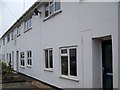
Shrewton houses [15]
On Rollestone Road is this fine pair of substantial semi-detached houses. These are similar to Image
The village of Shrewton is located on Salisbury Plain and is made up of several early communities and was, until 1934 three separate parishes. The name Shrewton comes from the Old English word for sheriff’s farm or settlement. The village lies on the east to west road from London to Bridgwater via Amesbury and Warminster. The River Till which rises near Tilshead flows through the village on its way to join the River Wylye near Stapleford.
Image: © Michael Dibb
Taken: 29 Jan 2020
0.11 miles
6
![Shrewton houses [25]](https://s3.geograph.org.uk/geophotos/06/40/18/6401879_f789509b_120x120.jpg)
Shrewton houses [25]
The Old Shop in Salisbury Road is now a private dwelling.
The village of Shrewton is located on Salisbury Plain and is made up of several early communities and was, until 1934 three separate parishes. The name Shrewton comes from the Old English word for sheriff’s farm or settlement. The village lies on the east to west road from London to Bridgwater via Amesbury and Warminster. The River Till which rises near Tilshead flows through the village on its way to join the River Wylye near Stapleford.
Image: © Michael Dibb
Taken: 29 Jan 2020
0.12 miles
7
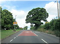
A360 passes The Royal Oak
The 'A' road is also known as the Amesbury Road at this point.
Image: © Stuart Logan
Taken: 25 Apr 2013
0.12 miles
8
![Shrewton houses [24]](https://s2.geograph.org.uk/geophotos/06/40/18/6401878_7f9d08c6_120x120.jpg)
Shrewton houses [24]
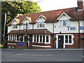
Wheatsheaf House was once The Wheatsheaf public house. At one time there were six public houses in the village - at the present time there is only one.
The village of Shrewton is located on Salisbury Plain and is made up of several early communities and was, until 1934 three separate parishes. The name Shrewton comes from the Old English word for sheriff’s farm or settlement. The village lies on the east to west road from London to Bridgwater via Amesbury and Warminster. The River Till which rises near Tilshead flows through the village on its way to join the River Wylye near Stapleford.
Image: © Michael Dibb
Taken: 29 Jan 2020
0.12 miles
9
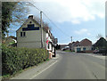
Flood cottages, Shrewton
These cottages were built to house victims of flooding in 1841.
Image: © Maigheach-gheal
Taken: 1 Jan 2009
0.12 miles
10
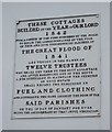
Plaque on cottages, Shrewton
The plaque on Image
Image: © Maigheach-gheal
Taken: 1 Jan 2009
0.13 miles