IMAGES TAKEN NEAR TO
London Road, SALISBURY, SP3 4DH
Introduction
This page details the photographs taken nearby to London Road, SP3 4DH by members of the Geograph project.
The Geograph project started in 2005 with the aim of publishing, organising and preserving representative images for every square kilometre of Great Britain, Ireland and the Isle of Man.

There are currently over 7.5m images from over14,400 individuals and you can help contribute to the project by visiting https://www.geograph.org.uk
Image Map
Images are licensed for reuse under creativecommons.org/licenses/by-sa/2.0
Notes
- Clicking on the map will re-center to the selected point.
- The higher the marker number, the further away the image location is from the centre of the postcode.
Image Listing (103 Images Found)
Images are licensed for reuse under creativecommons.org/licenses/by-sa/2.0
Image
Details
Distance
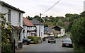
1
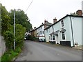
Shrewton, cottages
On London Road, at the base of the hill out of the village.
Image: © Mike Faherty
Taken: 3 Oct 2013
0.01 miles
3
![Shrewton houses [31]](https://s2.geograph.org.uk/geophotos/07/38/05/7380574_a8acabac_120x120.jpg)
Shrewton houses [31]
Kuching Cottage, London Road, was built in the early 19th century with a bay added on the left in the 19th century and a 20th century rear extension. Constructed of plastered cob under a hipped Welsh slate roof. Listed, grade II, with details at: https://historicengland.org.uk/listing/the-list/list-entry/1355663
The village of Shrewton is located on Salisbury Plain and is made up of several early communities and was, until 1934 three separate parishes. The name Shrewton comes from the Old English word for sheriff’s farm or settlement. The village lies on the east to west road from London to Bridgwater via Amesbury and Warminster. The River Till which rises near Tilshead flows through the village on its way to join the River Wylye near Stapleford.
Image: © Michael Dibb
Taken: 2 Jan 2023
0.02 miles
4
![Shrewton houses [30]](https://s2.geograph.org.uk/geophotos/07/38/05/7380566_efc0948a_120x120.jpg)
Shrewton houses [30]
Numbers 1 and 2 Sundial Cottages, London Road, have a large sundial mounted between the two cottages. Constructed of brick under a tile roof.
The village of Shrewton is located on Salisbury Plain and is made up of several early communities and was, until 1934 three separate parishes. The name Shrewton comes from the Old English word for sheriff’s farm or settlement. The village lies on the east to west road from London to Bridgwater via Amesbury and Warminster. The River Till which rises near Tilshead flows through the village on its way to join the River Wylye near Stapleford.
Image: © Michael Dibb
Taken: 2 Jan 2023
0.03 miles
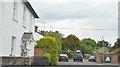
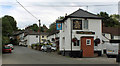
6
The George Inn, Maddington
At the foot of the old London Road.
Image: © Dr Duncan Pepper
Taken: 15 Mar 2009
0.03 miles
7
2011 : B3086 London Road, Maddington
The road makes a sharp turn right just beyond the cross of St. George where it becomes High Street. Straight on along Elston Lane to Elston and Orcheston.
Image: © Maurice Pullin
Taken: 25 Jul 2011
0.04 miles
8
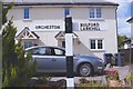
Old Direction Sign - Signpost by the B3086, London Road, Maddington
Pyramid top finial - 2 arms; Wilts. wooden by the B3086, in parish of Shrewton (Salisbury District), junction with lanes to Orcheston and Maddington.
Surveyed
Milestone Society National ID: WI_SU0744
Image: © Milestone Society
Taken: Unknown
0.04 miles
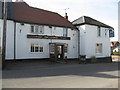
9
2011 : The George, Maddington
A former coaching inn on the London Road.
Image: © Maurice Pullin
Taken: 25 Jul 2011
0.04 miles
10
![Shrewton houses [30]](https://s3.geograph.org.uk/geophotos/07/38/05/7380555_266e0c42_120x120.jpg)
Shrewton houses [30]
Whiteways, High Street, is a detached house built in the early 19th century and was renovated in the mid 1980s. Constructed of cob under a hipped Welsh slate roof. Some original internal features and fittings remain. Listed, grade II, with details at: https://historicengland.org.uk/listing/the-list/list-entry/1182047
The village of Shrewton is located on Salisbury Plain and is made up of several early communities and was, until 1934 three separate parishes. The name Shrewton comes from the Old English word for sheriff’s farm or settlement. The village lies on the east to west road from London to Bridgwater via Amesbury and Warminster. The River Till which rises near Tilshead flows through the village on its way to join the River Wylye near Stapleford.
Image: © Michael Dibb
Taken: 2 Jan 2023
0.05 miles