IMAGES TAKEN NEAR TO
Catherine Court, SALISBURY, SP3 4BT
Introduction
This page details the photographs taken nearby to Catherine Court, SP3 4BT by members of the Geograph project.
The Geograph project started in 2005 with the aim of publishing, organising and preserving representative images for every square kilometre of Great Britain, Ireland and the Isle of Man.

There are currently over 7.5m images from over14,400 individuals and you can help contribute to the project by visiting https://www.geograph.org.uk
Image Map
Images are licensed for reuse under creativecommons.org/licenses/by-sa/2.0
Notes
- Clicking on the map will re-center to the selected point.
- The higher the marker number, the further away the image location is from the centre of the postcode.
Image Listing (117 Images Found)
Images are licensed for reuse under creativecommons.org/licenses/by-sa/2.0
Image
Details
Distance
1
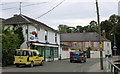
![Shrewton buildings [1]](https://s0.geograph.org.uk/geophotos/06/39/87/6398788_8a2da5cb_120x120.jpg)
Shrewton buildings [1]
This early 19th century building was once The Catherine Wheel public house. Closed circa 1998 and now in private residential use. Listed, grade II, with details at: https://historicengland.org.uk/listing/the-list/list-entry/1181968
The village of Shrewton is located on Salisbury Plain and is made up of several early communities and was, until 1934 three separate parishes. The name Shrewton comes from the Old English word for sheriff’s farm or settlement. The village lies on the east to west road from London to Bridgwater via Amesbury and Warminster. The River Till which rises near Tilshead flows through the village on its way to join the River Wylye near Stapleford.
Image: © Michael Dibb
Taken: 29 Jan 2020
0.01 miles
2
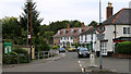
2011 : B3086 at Shrewton
High Street, passing the post office and general store. Near the end of the road.
In its short six mile journey from the A345 near Durrington the B3086 has flirted with the Military Range, passing through Larkhill camp, and seen a few cornfields. It was once a packhorse way.
Image: © Maurice Pullin
Taken: 25 Jul 2011
0.01 miles
3
2011 : B3086 High Street, Shrewton looking north
The western end of the B3086 seen from the A360.
Image: © Maurice Pullin
Taken: 25 Jul 2011
0.02 miles
4
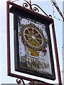
Sign of the Times
This old pub sign was still standing but the pub appears to have been converted into sheltered housing or similar where the name, Catherine, continues. The village of Shrewton still has three other pubs - George, Plume of Feathers and Royal Oak.
Image: © Colin Smith
Taken: 10 Mar 2007
0.02 miles
5
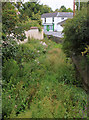
2011 : Winterbourne, Shrewton
A winterbourne or winterborne is a river or stream which is dry during the summer months, this one passes through Shrewton. The word is believed to have Anglo Saxon origins.
This is the headwaters of the River Till (or will be next winter).
Image: © Maurice Pullin
Taken: 25 Jul 2011
0.03 miles
6
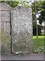
Old Milestone by the A360, Maddington, Shrewton parish
Carved stone post by the A360, in parish of SHREWTON (SALISBURY District), Maddington Street, Shrewton, by 'Blind House' against wall on verge, on West side of road. Amesbury stone, erected by the Amesbury turnpike trust in the 18th century.
Inscription reads:-
LXXXIV
Miles from
London
(V)I From
Amefbury
Grade II listed.
List Entry Number: 1182061 https://historicengland.org.uk/listing/the-list/list-entry/1182061
Milestone Society National ID: WI_AMHE06.
Image: © M Faherty
Taken: 4 Jun 2007
0.03 miles
7
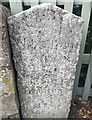
Old Milestone by the A360, Maddington, Shrewton parish
Carved stone post by the A360, in parish of SHREWTON (SALISBURY District), Maddington Street, Shrewton, by 'Blind House' against wall on verge, on West side of road. Amesbury stone, erected by the Amesbury turnpike trust in the 18th century. An earlier photograph can be seen here https://www.geograph.org.uk/photo/6050720.
Inscription reads:-
LXXXIV
Miles from
London
(V)I From
Amefbury
Grade II listed.
List Entry Number: 1182061 https://historicengland.org.uk/listing/the-list/list-entry/1182061
Milestone Society National ID: WI_AMHE06.
Image: © Gail Fawcett
Taken: 1 Aug 2023
0.03 miles
8
![Shrewton features [11]](https://s3.geograph.org.uk/geophotos/06/40/18/6401895_e10c0bb4_120x120.jpg)
Shrewton features [11]
This view shows in context the milestone and the Blind House or lock up.
The Blind House, known locally as the Round House is circa 1700 and was in use as a lock up until the end of the 19th century. It has been rebuilt twice. Listed, grade II, with details at: https://historicengland.org.uk/listing/the-list/list-entry/1024000 Closer views are at Image and Image
The milestone is late 18th century and is incised LXXXIV miles from London VI from Amesbury. Listed, grade II, with details at: https://historicengland.org.uk/listing/the-list/list-entry/1182061 A closer view is at Image
The village of Shrewton is located on Salisbury Plain and is made up of several early communities and was, until 1934 three separate parishes. The name Shrewton comes from the Old English word for sheriff’s farm or settlement. The village lies on the east to west road from London to Bridgwater via Amesbury and Warminster. The River Till which rises near Tilshead flows through the village on its way to join the River Wylye near Stapleford.
Image: © Michael Dibb
Taken: 29 Jan 2020
0.04 miles
9
![Shrewton features [12]](https://s2.geograph.org.uk/geophotos/06/40/19/6401938_dc92b16f_120x120.jpg)
Shrewton features [12]
The Blind House, known locally as the Round House is circa 1700 and was in use as a lock up until the end of the 19th century. It has been rebuilt twice. Listed, grade II, with details at: https://historicengland.org.uk/listing/the-list/list-entry/1024000 The Blind House is seen in context at Image and there is a closer view at Image
The village of Shrewton is located on Salisbury Plain and is made up of several early communities and was, until 1934 three separate parishes. The name Shrewton comes from the Old English word for sheriff’s farm or settlement. The village lies on the east to west road from London to Bridgwater via Amesbury and Warminster. The River Till which rises near Tilshead flows through the village on its way to join the River Wylye near Stapleford.
Image: © Michael Dibb
Taken: 29 Jan 2020
0.04 miles
10
![Shrewton features [13]](https://s0.geograph.org.uk/geophotos/06/40/19/6401940_2a6d7d46_120x120.jpg)
Shrewton features [13]
A plaque on the door of the Blind House.
The Blind House, known locally as the Round House is circa 1700 and was in use as a lock up until the end of the 19th century. It has been rebuilt twice. Listed, grade II, with details at: https://historicengland.org.uk/listing/the-list/list-entry/1024000 The Blind House is seen in context at Image and a closer view is at Image
The village of Shrewton is located on Salisbury Plain and is made up of several early communities and was, until 1934 three separate parishes. The name Shrewton comes from the Old English word for sheriff’s farm or settlement. The village lies on the east to west road from London to Bridgwater via Amesbury and Warminster. The River Till which rises near Tilshead flows through the village on its way to join the River Wylye near Stapleford.
Image: © Michael Dibb
Taken: 29 Jan 2020
0.04 miles