IMAGES TAKEN NEAR TO
Wilton Road, SALISBURY, SP3 4AD
Introduction
This page details the photographs taken nearby to Wilton Road, SP3 4AD by members of the Geograph project.
The Geograph project started in 2005 with the aim of publishing, organising and preserving representative images for every square kilometre of Great Britain, Ireland and the Isle of Man.

There are currently over 7.5m images from over14,400 individuals and you can help contribute to the project by visiting https://www.geograph.org.uk
Image Map
Images are licensed for reuse under creativecommons.org/licenses/by-sa/2.0
Notes
- Clicking on the map will re-center to the selected point.
- The higher the marker number, the further away the image location is from the centre of the postcode.
Image Listing (67 Images Found)
Images are licensed for reuse under creativecommons.org/licenses/by-sa/2.0
Image
Details
Distance
1
![Barford St Martin houses [1]](https://s0.geograph.org.uk/geophotos/07/19/23/7192372_22a96240_120x120.jpg)
Barford St Martin houses [1]
East End Farmhouse, Wilton Road, was probably built circa 1600 and altered in the late 17th century. On the left is a 19th century extension and there is a cross wing to the rear. Constructed of rubble stone under a tile roof. Listed, grade II, with details at: https://historicengland.org.uk/listing/the-list/list-entry/1146194
Barford St Martin is a village in Wiltshire, some 2½ miles west of Wilton. The village is set on the north bank of the River Nadder at the junction of the B3089 road with the A30 road. There is evidence of occupation from the Iron Age onwards. Most working residents commute to Wilton or to Salisbury.
Image: © Michael Dibb
Taken: 20 Apr 2022
0.02 miles
2
![Barford St Martin houses [2]](https://s1.geograph.org.uk/geophotos/07/19/23/7192373_9d8f922f_120x120.jpg)
Barford St Martin houses [2]
Hill Cottage, Wilton Road, is an 18th century detached cottage. Constructed of rubble stone and brick, the front rendered, all under a thatch roof. Listed, grade II, with details at: https://historicengland.org.uk/listing/the-list/list-entry/1182983
Barford St Martin is a village in Wiltshire, some 2½ miles west of Wilton. The village is set on the north bank of the River Nadder at the junction of the B3089 road with the A30 road. There is evidence of occupation from the Iron Age onwards. Most working residents commute to Wilton or to Salisbury.
Image: © Michael Dibb
Taken: 20 Apr 2022
0.06 miles
3
![Barford St Martin houses [5]](https://s2.geograph.org.uk/geophotos/07/19/24/7192458_f5291eaf_120x120.jpg)
Barford St Martin houses [5]
Shashton Way Cottage, Wilton Road, built gable end to the street, is a 17th century detached cottage. Constructed of rubble stone under a thatch roof. Listed, grade II, with details at: https://historicengland.org.uk/listing/the-list/list-entry/1146191
Barford St Martin is a village in Wiltshire, some 2½ miles west of Wilton. The village is set on the north bank of the River Nadder at the junction of the B3089 road with the A30 road. There is evidence of occupation from the Iron Age onwards. Most working residents commute to Wilton or to Salisbury.
Image: © Michael Dibb
Taken: 20 Apr 2022
0.10 miles
4
![Barford St Martin houses [3]](https://s0.geograph.org.uk/geophotos/07/19/23/7192376_1ea4398e_120x120.jpg)
Barford St Martin houses [3]
Barford Forge, Wilton Road, was originally two cottages and a forge, now one semi-detached house. Built in the 17th century, the cottages are timber framed with brick noggin, now painted. The former forge, on the right, is of dressed limestone, all under a half-hipped thatch roof. There is a 20th century gabled porch to the left return and there is a 20th century extension to the rear. Some original internal features remain. Listed, grade II, with details at: https://historicengland.org.uk/listing/the-list/list-entry/1146193
Barford St Martin is a village in Wiltshire, some 2½ miles west of Wilton. The village is set on the north bank of the River Nadder at the junction of the B3089 road with the A30 road. There is evidence of occupation from the Iron Age onwards. Most working residents commute to Wilton or to Salisbury.
Image: © Michael Dibb
Taken: 20 Apr 2022
0.10 miles
5
![Barford St Martin houses [4]](https://s1.geograph.org.uk/geophotos/07/19/23/7192377_a19e1f6c_120x120.jpg)
Barford St Martin houses [4]
The Hill, Wilton Road, is an 18th century semi-detached cottage. Constructed of dressed limestone and rubble stone, now painted, under a thatch roof. There is a 20th century brick extension to the right. Listed, grade II, with details at: https://historicengland.org.uk/listing/the-list/list-entry/1182999
Barford St Martin is a village in Wiltshire, some 2½ miles west of Wilton. The village is set on the north bank of the River Nadder at the junction of the B3089 road with the A30 road. There is evidence of occupation from the Iron Age onwards. Most working residents commute to Wilton or to Salisbury.
Image: © Michael Dibb
Taken: 20 Apr 2022
0.11 miles
6
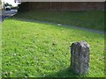
Milestone, Barford St Martin
Late 18th century limestone pillar beside the A30. The Salisbury to East Knoyle road was turnpiked 1760-1762.
Image: © Maigheach-gheal
Taken: 18 Oct 2009
0.12 miles
7
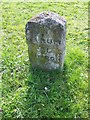
Milestone, Barford St Martin
The milestone indicates that Sarum (Salisbury) is VI miles away and Hindon is X miles away. For a wider view see Image]
Image: © Maigheach-gheal
Taken: 18 Oct 2009
0.13 miles
8
![Barford St Martin features [2]](https://s3.geograph.org.uk/geophotos/07/19/24/7192467_b0249fb2_120x120.jpg)
Barford St Martin features [2]
This milestone on Wilton Road was erected in the later 18th century when the road from Salisbury to East Knoyle road was turnpiked in 1760-62. A limestone pillar with a pitched top. The lettering reads: SARUM / VI / HINDON / X. The milestone is seen in context at Image Listed, grade II, with details at: https://historicengland.org.uk/listing/the-list/list-entry/1146192
Barford St Martin is a village in Wiltshire, some 2½ miles west of Wilton. The village is set on the north bank of the River Nadder at the junction of the B3089 road with the A30 road. There is evidence of occupation from the Iron Age onwards. Most working residents commute to Wilton or to Salisbury.
Image: © Michael Dibb
Taken: 20 Apr 2022
0.13 miles
9

Old Milestone by the A30, Wilton Road, Barford St Martin
Carved stone post by the A30, in parish of BARFORD ST MARTIN (SALISBURY District), Wilton Road; opposite junction with Groveley Road, on green, on South side of road. Hindon stone, erected by the Fisherton, Wilton, Heytesbury, Willoughby Hedge & Redhone turnpike trust in the 19th century.
Inscription reads:-
SARUM
VI
HINDON
X
Grade II listed.
List Entry Number: 1146192 https://historicengland.org.uk/listing/the-list/list-entry/1146192
Milestone Society National ID: WI_SAMR06.
Image: © M Faherty
Taken: 4 Feb 2007
0.13 miles
10
![Barford St Martin features [1]](https://s1.geograph.org.uk/geophotos/07/19/24/7192465_e92c3d1e_120x120.jpg)
Barford St Martin features [1]
This milestone on Wilton Road was erected in the later 18th century when the road from Salisbury to East Knoyle road was turnpiked in 1760-62. A limestone pillar with a pitched top. The lettering reads: SARUM / VI / HINDON / X. There is a closer view of the milestone at Image Listed, grade II, with details at: https://historicengland.org.uk/listing/the-list/list-entry/1146192
Barford St Martin is a village in Wiltshire, some 2½ miles west of Wilton. The village is set on the north bank of the River Nadder at the junction of the B3089 road with the A30 road. There is evidence of occupation from the Iron Age onwards. Most working residents commute to Wilton or to Salisbury.
Image: © Michael Dibb
Taken: 20 Apr 2022
0.13 miles