IMAGES TAKEN NEAR TO
Lower Road, SALISBURY, SP2 9NH
Introduction
This page details the photographs taken nearby to Lower Road, SP2 9NH by members of the Geograph project.
The Geograph project started in 2005 with the aim of publishing, organising and preserving representative images for every square kilometre of Great Britain, Ireland and the Isle of Man.

There are currently over 7.5m images from over14,400 individuals and you can help contribute to the project by visiting https://www.geograph.org.uk
Image Map
Images are licensed for reuse under creativecommons.org/licenses/by-sa/2.0
Notes
- Clicking on the map will re-center to the selected point.
- The higher the marker number, the further away the image location is from the centre of the postcode.
Image Listing (138 Images Found)
Images are licensed for reuse under creativecommons.org/licenses/by-sa/2.0
Image
Details
Distance
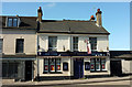
1
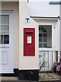
George V Postbox, Lower Bemerton
The door on the left was once the door to the post office.
Image: © Maigheach-gheal
Taken: 15 Jul 2008
0.02 miles
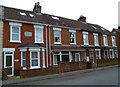
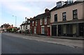
2
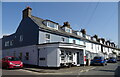
Houses on Lower Road
See https://www.geograph.org.uk/photo/7318333 for postbox.
Showing position of Postbox No. SP2 99.
Image: © JThomas
Taken: 22 Mar 2022
0.03 miles
3
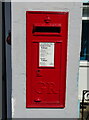
George V postbox on Lower Road
See https://www.geograph.org.uk/photo/7318337 for context.
Postbox No. SP2 99.
Image: © JThomas
Taken: 22 Mar 2022
0.03 miles
4
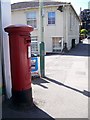
George V Postbox, Salisbury
This box is on Wilton Road.
Image: © Maigheach-gheal
Taken: 21 Jul 2008
0.08 miles
5
The Orange Way in Wiltshire (160)
The unusual name of this short terrace caught my eye.
Image: © Shazz
Taken: 22 Apr 2013
0.08 miles
6
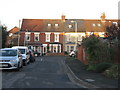
Houses on Lower Road, Bemerton
Looking north from Hadrian's Close.
Image: © M J Richardson
Taken: 24 Dec 2015
0.09 miles
7
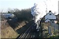
Bittern leaving Salisbury
A steam excursion hauled by A4 ex LNER Pacific 60019 "Bittern", which usually works on the Mid Hants Railway. The excursion, from Haywards Heath to Bath, was running nearly an hour late. It had stopped at Hedge End and Salisbury stations for water, so we took the opportunity to drive to this location where we hoped to get a shot with the cathedral in the background. Unfortunately she was making such a fuss of accelerating away to make up some lost time that the cathedral is lost in there somewhere.
Image: © Graham Horn
Taken: 6 Dec 2008
0.09 miles
8
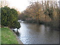
The River Nadder, looking east
A view downstream towards Salisbury from Bemerton.
Image: © M J Richardson
Taken: 24 Dec 2015
0.10 miles
10
Halfway House, Wilton Road
Also shown at https://www.geograph.org.uk/search.php?i=85172056 .
Image: © Derek Harper
Taken: 30 Jun 2018
0.10 miles