IMAGES TAKEN NEAR TO
Heath View Drive, SALISBURY, SP2 9LP
Introduction
This page details the photographs taken nearby to Heath View Drive, SP2 9LP by members of the Geograph project.
The Geograph project started in 2005 with the aim of publishing, organising and preserving representative images for every square kilometre of Great Britain, Ireland and the Isle of Man.

There are currently over 7.5m images from over14,400 individuals and you can help contribute to the project by visiting https://www.geograph.org.uk
Image Map
Images are licensed for reuse under creativecommons.org/licenses/by-sa/2.0
Notes
- Clicking on the map will re-center to the selected point.
- The higher the marker number, the further away the image location is from the centre of the postcode.
Image Listing (14 Images Found)
Images are licensed for reuse under creativecommons.org/licenses/by-sa/2.0
Image
Details
Distance
2
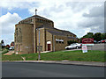
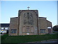
St Michael's Church & Community Centre - Salisbury Outskirts
Image: © Mike Searle
Taken: 20 Jun 2007
0.13 miles
3
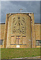
Detail on St Michael's Church - Salisbury Outskirts
Image: © Mike Searle
Taken: 20 Jun 2007
0.14 miles
4
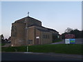
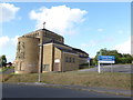
Bemerton Heath: St. Michael & All Angels? church
Pictured not long before dusk, this bulky modern building stands on St. Michael's Road, at the brow of the hill.
See Image for detail of the stonework facing the road.
Image: © Chris Downer
Taken: 10 Nov 2013
0.14 miles
5
Bemerton Heath: detail of St. Michael?s church
A closer look at the artistic stonework of Image
Image: © Chris Downer
Taken: 10 Nov 2013
0.14 miles
7
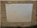
St Michael, Salisbury: foundation stone
For more about Lord Herbert see https://en.wikipedia.org/wiki/Sidney_Herbert,_16th_Earl_of_Pembroke and for more about Bishop William see https://en.wikipedia.org/wiki/William_Anderson_(bishop_of_Salisbury)
Image: © Basher Eyre
Taken: 19 Aug 2016
0.15 miles
8
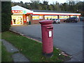
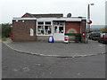
Bemerton Heath: postbox № SP2 439, Gainsborough Close
An Elizabeth II-reign postbox outside a surprisingly large Spar grocery store.
Image: © Chris Downer
Taken: 10 Nov 2013
0.20 miles
9
Bemerton Heath: the post office and postbox № SP2 390
This post office is contained within a general store on Pembroke Road. The George V-reign postbox is emptied for the last time at 5:15pm on weekdays and at noon on Saturdays.
Image: © Chris Downer
Taken: 1 Nov 2008
0.20 miles
10
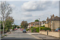
Coronation Road
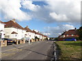
Road between Roman Road and Queen Alexandra Road. The road was first marked on the 1925 25 inch map, including some of the houses seen here. With neighbouring roads on that map of a King Edward Road (not actually developed, the line now being just a nameless track), Queen Alexandra Road and Empire Road, it would seem that the coronation the road name refers to was that of Edward VII in 1902; the 1925 map was the first survey after that date so there is none earlier to confirm or contradict this suggestion.
Image: © Ian Capper
Taken: 22 Sep 2022
0.22 miles