IMAGES TAKEN NEAR TO
Woodside Road, SALISBURY, SP2 9EF
Introduction
This page details the photographs taken nearby to Woodside Road, SP2 9EF by members of the Geograph project.
The Geograph project started in 2005 with the aim of publishing, organising and preserving representative images for every square kilometre of Great Britain, Ireland and the Isle of Man.

There are currently over 7.5m images from over14,400 individuals and you can help contribute to the project by visiting https://www.geograph.org.uk
Image Map (Loading...)


Getting Data...Please wait
Leaflet Map data © OpenStreetMap
Images are licensed for reuse under creativecommons.org/licenses/by-sa/2.0
Notes
- Clicking on the map will re-center to the selected point.
- The higher the marker number, the further away the image location is from the centre of the postcode.
Image Listing (7 Images Found)
Images are licensed for reuse under creativecommons.org/licenses/by-sa/2.0
Image
Details
Distance
1
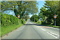
A360 Devizes Road, Salisbury
Heading out of town.
Image: © Robin Webster
Taken: 30 May 2021
0.15 miles
2
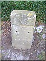
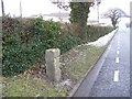
Milestone, Fugglestone Red
Milestone beside the A360, Devizes Road. The plate is missing, but the bench mark is just visible. For a wider view see Image
Image: © Maigheach-gheal
Taken: 12 Jan 2010
0.18 miles
3
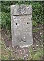
Old Milestone by the A360, Devizes Road, Bemerton Heath
Stone post (plate lost) by the A360, in parish of SALISBURY (SALISBURY District), Devizes Road, Bemerton Heath; 250m South of Fugglestone Red roundabout, on the verge, on West side of the A360 road. Salisbury plate, erected by the Fisherton, Wilton, Heytesbury, Willoughby Hedge & Redhone turnpike trust in the 19th century.
Inscription once read:-
(Salisbury)
(2)
(Devizes)
(21)
Carved benchmark lower front centre.
Milestone Society National ID: WI_DZSA21.
Image: © M Faherty
Taken: 28 May 2007
0.18 miles
4
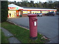
Bemerton Heath: postbox № SP2 439, Gainsborough Close
An Elizabeth II-reign postbox outside a surprisingly large Spar grocery store.
Image: © Chris Downer
Taken: 10 Nov 2013
0.19 miles
5
Milestone, Fugglestone Red
Milestone beside the A360, Devizes Road.
Image: © Maigheach-gheal
Taken: 12 Jan 2010
0.20 miles
6
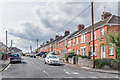
Heath Road
c.1920s housing, first marked on the 1938 25 inch map.
Image: © Ian Capper
Taken: 22 Sep 2022
0.21 miles
7
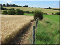
Farmland, Salisbury
On the hillside between the River Avon and the suburb of Bemerton Heath.
Image: © Andrew Smith
Taken: 5 Aug 2007
0.22 miles