IMAGES TAKEN NEAR TO
Pembroke Road, SALISBURY, SP2 9DG
Introduction
This page details the photographs taken nearby to Pembroke Road, SP2 9DG by members of the Geograph project.
The Geograph project started in 2005 with the aim of publishing, organising and preserving representative images for every square kilometre of Great Britain, Ireland and the Isle of Man.

There are currently over 7.5m images from over14,400 individuals and you can help contribute to the project by visiting https://www.geograph.org.uk
Image Map (Loading...)


Getting Data...Please wait
Leaflet Map data © OpenStreetMap
Images are licensed for reuse under creativecommons.org/licenses/by-sa/2.0
Notes
- Clicking on the map will re-center to the selected point.
- The higher the marker number, the further away the image location is from the centre of the postcode.
Image Listing (122 Images Found)
Images are licensed for reuse under creativecommons.org/licenses/by-sa/2.0
Image
Details
Distance
1
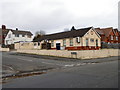
Pembroke Park Club, Salisbury
The club is situated in the former Labour Hall. There is an Ordnance Survey bench mark on the west angle.
Image: © Maigheach-gheal
Taken: 9 Jan 2012
0.02 miles
2
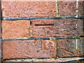
Bench Mark, Pembroke Park Club
The Ordnance Survey bench mark is to be found on the west angle of the former Labour Hall (now the Pembroke Park Social Club). For a wider view of the building Image and for further information on the cut mark and others in the area http://www.bench-marks.org.uk/bm40888
Image: © Maigheach-gheal
Taken: 9 Jan 2012
0.02 miles
3
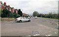
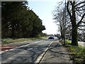
South-east on Pembroke Road
Looking down Pembroke Road from the junction with Queen Alexandra Road (Image) towards its junction with Wilton Road at Skew Bridge.
Image: © Jonathan Kington
Taken: 9 Jan 2012
0.04 miles
4
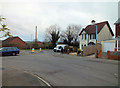
Road junction
The junction of Queen Alexandra Road with Pembroke Road at the bottom, there is a benchmark on the side of the house on the corner (For details of the mark visit http://www.bench-marks.org.uk/bm40890 ).
Image: © Jonathan Kington
Taken: 9 Jan 2012
0.07 miles
6
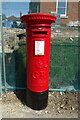
George V postbox on Pembroke Road
Postbox No. SP2 226.
Image: © JThomas
Taken: 22 Mar 2022
0.08 miles
7
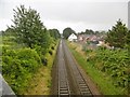
Salisbury, railway lines
Lines from Bristol and Exeter to Waterloo, seen from Skew Bridge.
Image: © Mike Faherty
Taken: 22 Jul 2017
0.10 miles
9
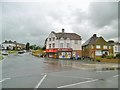
Bemerton, Bargain Stop
Convenience store at the corner of Wilton and Roman Roads.
Image: © Mike Faherty
Taken: 22 Jul 2017
0.10 miles
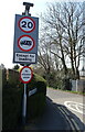
10
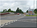
Salisbury - Skew Bridge
Looking across Skew Bridge.
Image: © Chris Talbot
Taken: 10 Jul 2011
0.11 miles