IMAGES TAKEN NEAR TO
Folkestone Road, SALISBURY, SP2 8JP
Introduction
This page details the photographs taken nearby to Folkestone Road, SP2 8JP by members of the Geograph project.
The Geograph project started in 2005 with the aim of publishing, organising and preserving representative images for every square kilometre of Great Britain, Ireland and the Isle of Man.

There are currently over 7.5m images from over14,400 individuals and you can help contribute to the project by visiting https://www.geograph.org.uk
Image Map
Images are licensed for reuse under creativecommons.org/licenses/by-sa/2.0
Notes
- Clicking on the map will re-center to the selected point.
- The higher the marker number, the further away the image location is from the centre of the postcode.
Image Listing (89 Images Found)
Images are licensed for reuse under creativecommons.org/licenses/by-sa/2.0
Image
Details
Distance
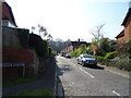
2
Bridleway, Harnham Slope
Bridleway SALS 16 runs below steep woodland and above housing on Folkestone Road and Hollows Close.
Image: © Derek Harper
Taken: 30 Jun 2018
0.05 miles
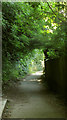
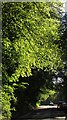
3
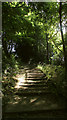
Steps on Harnham Slope
Carrying footpath SALS 15 up the steep woodland.
Image: © Derek Harper
Taken: 30 Jun 2018
0.07 miles
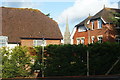
5
![Salisbury houses [13]](https://s0.geograph.org.uk/geophotos/06/39/20/6392004_c426b7ef_120x120.jpg)
Salisbury houses [13]
This private drive leads to almshouses and other sheltered housing for older people. The properties are managed by Salisbury City Almshouse and Welfare Charities. Their history reaches back to deeds of benefaction in the 1370s. Their website is at: http://www.salisburyalmshouses.co.uk/
A cathedral was established at the Iron Age hillfort of Old Sarum by the Normans. In 1220 the cathedral was removed to the nearby plain and New Sarum (Salisbury) grew up around it, receiving a city charter in 1227. Located at the confluence of five rivers (Avon, Nadder, Ebble, Wylye and Bourne) the city is prone to flooding. Traffic between the ports of Southampton and Bristol, passes around the city's ring-road via the A36 causing much congestion.
Image: © Michael Dibb
Taken: 31 Dec 2019
0.07 miles
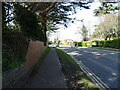
6

Bus stop, Harnham Road, Harnham
For services towards Salisbury.
Image: © Robin Webster
Taken: 16 Dec 2017
0.08 miles
7
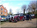
Waiting for the Bride
Cars in the car park of the Grasmere House Hotel.
Image: © Maigheach-gheal
Taken: 1 Dec 2007
0.08 miles
8
Old Blandford Road, Salisbury
Climbing Harnham Hill through woodland.
Image: © Derek Harper
Taken: 30 Jun 2018
0.08 miles
9
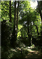
Woodland on Harnham Slope
Close to Old Blandford Road.
Image: © Derek Harper
Taken: 30 Jun 2018
0.08 miles
10
Cathedral View, Salisbury
With a two bedroom flat for sale, the Estate Agents will certainly play on the view across to Salisbury Cathedral.
Image: © Peter Trimming
Taken: 17 Nov 2009
0.08 miles